Climate Zones
Climate zones refer to areas that are having distinct climates, occurring particularly in the east-west direction around the Earth. Furthermore, there have always been variations in different climate zones that are present all over the Earth. This depends on the precipitation, weather and the general temperature of that particular area.
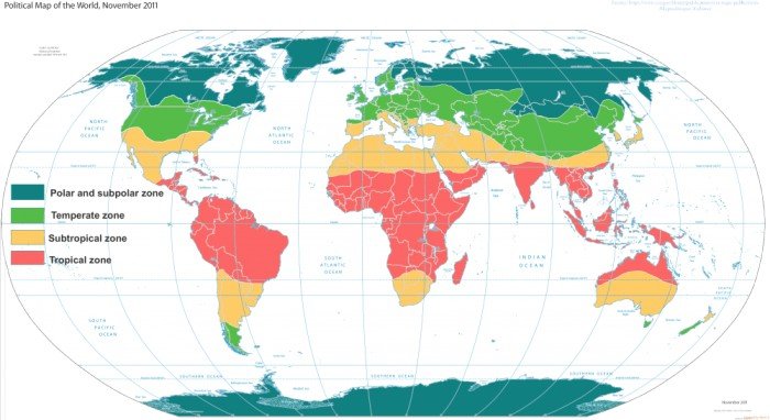
Climate zones are areas with distinct climates, which occur in east-west direction around the Earth, and can be classified using different climatic parametres. Generally, climate zones are belt-shaped and circular around the Poles (see picture on the right). In some areas, climate zones can be interrupted by mountains or oceans.
The solar radiation reaches the ground on different parts of the Earth with different angles. On the equator, the sunlight reaches the ground almost perpendicularly, whilst at the poles the angle of the Sun is lower or even under the horizon during the polar night.
Day Length
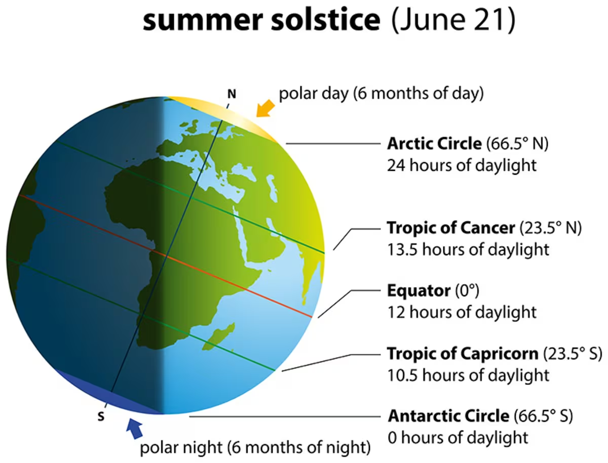
Throughout the seasons, the position of the Sun to the Earth and thus the angle of incidence of the sunlight also change. The angle of the Sun at noon varies from perpendicular (90° ) within the tropics up to horizontal (0 ∘ = Sun does not or only partially appear on the horizon) within the polar circle. Thus, the sunlight warms up the Earth around the equator much more strongly than at the poles. Due to temperature differences caused by the differences in radiation, recurring climatic conditions develop, such as winter and summer. These conditions are characterised by a certain amount of precipitation in summer or a certain average air temperature. Different climatic conditions, which arise regularly in certain areas, are summarized and described in the classification below.
There are 4 Major Climate Zones:
Tropical zone from 0° − 23.5° (Between the Tropics)
In the regions between the equator and the tropics (equatorial region), the solar radiation reaches the ground nearly vertically at noontime during almost the entire year. Thereby, it is very warm in these regions. Through high temperatures, more water evaporates and the air is often moist. The resulting frequent and dense cloud cover reduces the effect of solar radiation on ground temperature.
The tropical zone is present near to the equator and between the Tropic of Cancer in the Northern hemisphere of the Earth and the Tropic of Capricorn in the Southern hemisphere of the Earth. Moreover, the temperature prevalent in such areas on an average are always above 18° Celsius.
In those regions, the climate is usually warm. Furthermore, due to such high temperatures, more water evaporation takes place and the air becomes moist due to this in such regions.
Examples of Countries that fall under the tropical zone are countries of South America including Brazil, Peru, Bolivia, Ecuador along with the countries in Southeast Asia including Thailand, Cambodia, Vietnam, and Malaysia.
Subtropics from 𝟐𝟑. 𝟓° − 𝟒𝟎°
The subtropics receive the highest radiation in summer, since the Sun’s angle at noon is almost vertical to the Earth, whilst the cloud cover is relatively thin. These regions receive less moisture (see trade winds), what increases the effect of radiation. Therefore, most of the deserts in the world are situated in this zone. In winter, the radiation in these regions decreases significantly, and it can temporarily be very cool and moist.
Temperate zone from 𝟒𝟎° − 𝟔𝟎°
In the temperate zone, the solar radiation arrives with a smaller angle, and the average temperatures here are much cooler than in the subtropics. The seasons and daylength differ significantly in the course of a year. The climate is characterised by less frequent extremes, a more regular distribution of the precipitation over the year and a longer vegetation period – therefore the name “temperate”.
Temperate regions are such regions that are often referred to as middle latitude or mesothermal climates. Such areas are characterized by having little rainfall and in such areas, the summers are quite warm.
In the temperate regions, when the coldest months arrive, the temperature in those regions ranges between 26.6 ∘ to 64.4 ∘ Fahrenheit. Regions that fall under the temperate zones include marine regions, subtropical regions, and Mediterranean regions.
Examples of Countries that fall in the temperate zone include India, Japan, the United States of America, Canada, etc.
Polar Zone
Regions that fall under the polar zone have little or no summer. The warmest temperature in those regions on an average is around 50° Fahrenheit.
These regions become distinctive compared to other regions due to the presence of large blocks of permanent ice and tundra. Such regions also have months of very little daylight.
Examples of polar zones include the Arctic and the Antarctic along with Alaska, Sweden, and Finland.
Dry Zones
Dry zones include regions experiencing very little rainfall. Such regions also tend to have large ranges in daily temperatures. Talking about the deserts of such regions, the temperatures over there can reach over 120° Fahrenheit during the days and may fall up to 100° Fahrenheit or less during the nights.
Examples of dry zones include Northern Texas, Nevada, New Mexico, etc.
Cold zone from 𝟔𝟎° − 𝟗𝟎°
The polar areas between 60° latitude and the poles receive less heat through solar radiation, since the Sun has a very flat angle toward the ground. Because of the changes of the Earth axis angle to the Sun, the day length varies most in this zone. In the summer, polar days occur. Vegetation is only possible during a few months per year and even then is often sparse. The conditions for life in these regions are very hard.
Cold zones are also referred to as the continental or microthermal climates characterized by having high seasonal variations in temperatures and moderate rainfall. Such regions are found in the central regions of landmasses.
In the regions of the cold zones, the average temperature in summers may range between 70° to 90° Fahrenheit. However, the coldest months of such regions have an average temperature below 26° Fahrenheit.
Examples of cold zones include Iceland, Denmark, Norway, etc.
The characteristics of the climate zones change with great altitude differences within a small area, like in mountain areas, since temperatures decrease rapidly with altitude, changing the climate compared to valleys.
Climatic Regions of World
Climate is a measure of the average pattern of variation in temperature, humidity, atmospheric pressure, wind, precipitation, atmospheric particle count, and other meteorological variables in a given region over long periods of time.
Any independent study of each of these elements does not present any comprehensive view of climate. On the basis of these elements, there could be thousands of types of climates in the world.
Weather
- Weather, state of the atmosphere at a particular place during a short period of time. It involves such atmospheric phenomena as temperature, humidity, precipitation (type and amount), air pressure, wind, and cloud cover.
- The weather differs from the climate in that the latter includes the synthesis of weather conditions that have prevailed over a given area during a long time period – generally 30 years.
- Weather, as most commonly defined, occurs in the troposphere, the lowest region of the atmosphere that extends from the Earth’s surface to 6–8 km (4–5 miles) at the poles and to about 17 km (11 miles) at the Equator.
- Weather is largely confined to the troposphere since this is where almost all clouds occur and almost all precipitation develops. Phenomena occurring in higher regions of the troposphere and above, such as jet streams and upper-air waves, significantly affect sea-level atmospheric-pressure patterns – the so-called highs and lows – and thereby the weather conditions at the terrestrial surface.
- Geographic features, most notably mountains and large bodies of water (e.g., lakes and oceans), also affect weather.
- Recent research, for example, has revealed that ocean-surface temperature anomalies are a potential cause of atmospheric temperature anomalies in successive seasons and at distant locations. One manifestation of such weather-affecting interactions between the ocean and the atmosphere is what scientists call the El Niño/Southern Oscillation (ENSO).
Climate
- Climate, conditions of the atmosphere at a particular location over a long period of time; it is the long-term summation of the atmospheric elements (and their variations) that, over short time periods, constitute weather.
- These elements are solar radiation, temperature, humidity, precipitation (type, frequency, and amount), atmospheric pressure, and wind (speed and direction).
| Climatic Zone | Latitude (Approximate) | Climatic Type | Rainfall Regime (with approx. total) | Natural Vegetation |
|---|---|---|---|---|
| Equatorial Zone | 0°–10° N and S | 1. Hot, wet equatorial | Rainfall all year round: ~80 inches | Equatorial rain forests |
| Hot Zone | 10°–30° N and S | 2. Tropical Monsoon | Heavy summer rain: ~80 inches | Monsoon forests |
| 3. Tropical Marine | Much summer rain: ~70 inches | Savanna (tropical grassland) | ||
| 3. Sudan Type | Rain mainly in summer: ~30 inches | Savanna (tropical grassland) | ||
| 4. Desert: a) Saharan type | Little rainfall | Desert vegetation and scrub | ||
| 4. Desert: b) Mid-latitude type | Rain: ~5 inches | Desert vegetation and scrub | ||
| Warm Temperate Zone | 30°–40° N and S | 5. Western Margin (Mediterranean type) | Winter rain: ~35 inches | Mediterranean forests and scrub |
| 6. Central Continental (Steppe type) | Light summer rain: ~20 inches | Steppe or temperate grassland | ||
| 7. Eastern Margin: a) China type | Heavier summer rain: ~20 inches | Warm, wet forests and bamboo | ||
| 7. Eastern Margin: b) Gulf type | Heavy summer rain: ~20 inches | Warm, wet forests | ||
| Cool Temperate Zone | 45°–65° N and S | 8. Western Margin (British type) | More rain in autumn & winter: ~30 inches | Deciduous forests |
| 9. Central Continental (Siberian type) | Light summer rain: ~25 inches | Evergreen coniferous forests | ||
| 10. Eastern Margin (Laurentian type) | Moderate summer rain: ~40 inches | Mixed forests (coniferous and deciduous) | ||
| Cold Zone | 65°–90° N and S | 11. Arctic or Polar | Very light summer rain: ~10 inches | Tundra, mosses, lichens |
| Alpine Zone | High mountains | 12. Mountain climate | Heavy rainfall (variable) | Alpine pastures, conifers, fern, snow |
Climatic Regions of World
| Climatic Zone | Latitude (Approx.) | Climatic Type | Rainfall Characteristics (Approx.) | Natural Vegetation |
|---|---|---|---|---|
| Equatorial Zone | 0°–10° N & S | Hot Wet Equatorial | Rainfall throughout the year (~80 inches) | Equatorial rain forests |
| Hot Zone | 10°–30° N & S | Hot Desert | Very little rainfall | Desert vegetation |
| Sudan Type | Summer rainfall (~30 inches) | Savanna, tropical grassland | ||
| Monsoonal Type | Heavy summer rainfall (~80 inches) | Monsoon forests | ||
| Warm Temperate Zone | 30°–45° N & S | Mediterranean Type | Winter rainfall (~35 inches) | Mediterranean forests and shrubs |
| Steppe Type | Light summer rainfall (~20 inches) | Steppe (temperate grassland) | ||
| China Type | Heavy summer rainfall (~20 inches) | Warm wet forests | ||
| Cool Temperate Zone | 45°–65° N & S | British Type (Western Margin) | Rain mainly in winter (~30 inches) | Deciduous forests |
| Siberian Type (Central Continental) | Light summer rainfall (~25 inches) | Evergreen coniferous forests | ||
| Laurentian Type (Eastern Margin) | Moderate summer rainfall (~40 inches) | Mixed forests | ||
| Cold Zone | 65°–90° N & S | Arctic or Polar Type | Very low precipitation (~10 inches) | Tundra, mosses, lichens |
| Alpine Zone | High mountains (all latitudes) | Mountain Climate | Heavy rainfall (varies with altitude) | Alpine pastures, conifers, snow |
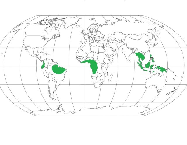
Hot, Wet Equatorial Climate
Distribution:
- 50 North – 100 South from equator
- No impact of trade winds, if you go away from this will have monsoon type climate.
- Basically, hot, wet type of climate but also have cool places like Cameron highland in Malaysia because these places are at high altitude.
- Examples of some Countries: Ecuador, Colombia, Brazil, Peru, Nigeria, Liberia, Myanmar, Thailand, Cambodia, Malaysia, Java
Climate:
- There is great uniformity of temperature throughout the year.
- The mean monthly temperatures are always around 24 to 27ºC, with very little variation.
- There is no winter.
- The diurnal and annual range of temperature is small.
- Precipitation is heavy between 6o inches and 10 inches, and well distributed throughout the year.
- The double rainfall peaks, coinciding with the equinoxes are a characteristics feature of it.
Natural Vegetation:
- It support a luxuriant type of vegetation – the tropical rain forest.
- Amazon tropical rain forest is known as Selvas.
- It comprises a multitude of evergreen trees that yield tropical hardwood, e.g. mahogany, ebony, greenheart, cabinet wood. And dyewoods.
- Lianas, epiphytic and parasitic plants are also found.
- Trees of single species are very scarce in such vegetation.
Economy:
- The equatorial regions are generally sparsely populated.
- In the forests, most primitive people live as hunters and collectors and the more advanced ones practice shifting cultivation.
- Some plantation crops are also practiced like natural rubber, cocoa, etc.
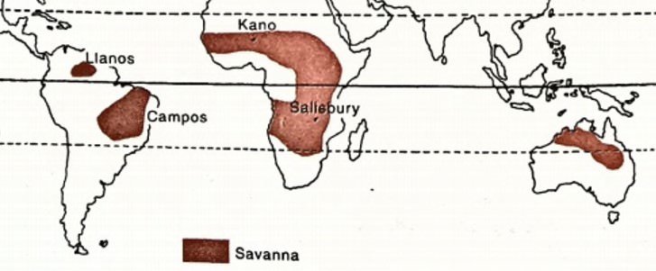
Savanna or Sudan Climate (or Tropical Wet and Dry Climate)
- Savanna or Sudan climate is a transitional type of climate found between the equatorial forests & trade wind hot deserts.
- It is confined within the tropics (Tropic of Cancer & Tropic of Capricorn) & is best developed in Sudan, where dry & wet climate are most distinct, hence named Sudan climate.
- It covers much of Africa (Keya, Nigeria, Gambia) as well as large areas of Australia, South America (Brazilian highlands), and India.
- Savana Climate has a distinct dry season which occurs in winter. All the rainfall in the region is concentrated during the summer. The long dry season causes many plants to die and streams to dry, which causes migration of animals.
Distribution:
- It is situated within the tropical latitudes on either side of the equator. It is well developed in Sudan, and hence the name, where there are distinct wet and dry seasons.
- In the northern hemisphere, this climate is found in Africa (African Sudan, East Africa), and South America (Llanos grasslands of Orinoco river basin).
- In the southern hemisphere, this climate is spread through South America (Campos grasslands of the Brazilian Highlands), and Australia (in Northern Australia – south of its monsoon strip).
Temperature:
- Monthly temperatures in this region can range between 20 to 32 degrees centigrade for lowlands, but the range increases as one moves away from the equator.
- Annual average temperature is around 18 degrees centigrade
- The highest temperature occurs just before the onset of the rainy season i.e., April in the northern hemisphere, and October in the southern hemisphere. June, when the summer solstice occurs in the northern hemisphere, does not witness the highest temperature.
- During the rainy season, overcast in the sky leads to drop in the temperatures.
- During the hot season, noon temperatures often cross 37 degrees centigrade.
- Clear skies lead to rapid radiation loss in the night and even in the hot season, the temperatures drop to below 10 degrees centigrade. Night frost is a common occurrence during this season
- Thus, a typical characteristic feature of Savanna climate is the extreme diurnal range of temperature.
Precipitation:
- The region is characterized by a hot, rainy season and cool, dry season.
- In the northern hemisphere, the hot and wet season starts in May and continues until September (e.g., Kano, in Nigeria). The rest of the year is dry and cool. Kano, which is located at an altitude of over 1500m above mean sea level, experiences over 80 cm of rainfall which happens mostly in the summer.
- In the southern hemisphere, the rainy season begins in October and ends in March.
- The length of the rainy season, as well as the total annual rainfall, decrease considerably as one moves away from the equator towards the desert fringes.
Winds:
- Trade-winds are the prevailing winds of the region which bring rainfall in the coastal areas. They are easterly winds – flow from east to west, hence the rainfall is maximum on the east coasts
- They are the strongest in summer when the ITCZ is positioned over the hot desert. They exhaust all the moisture while travelling over the coastal areas and by the time they reach the continental interiors, they are relatively dry.
- In West Africa, the easterly trade winds blow off-shore bringing dust-laden, dry winds from the Sahara and reach the coast of Guinea. The local name for this hot, dry, dusty wind is Harmattan (meaning ‘the doctor’).
- Harmattan has a disastrous effect on the crops, but it also results in a cooling effect. It provides some relief from the damp air of Guinea by increasing the rate of evaporation.
- Trade-winds are the reason for distinct, alternate dry and wet seasons in the region. In summer, onshore trade winds bring moisture-laden winds causing rainfall. In winter, the winds are off-shore and keep the weather dry.
Vegetation:
- The typical vegetation of this region is tall grass with short trees. The grassland is also described as ‘bush-veld’ or ‘parkland’.
- Tree cover is the highest towards the equator, along with the river banks and decreases in density and height away from the equator.
- The trees are of the deciduous variety i.e., they shed their leaves during the dry and cool season in order to prevent transpiration losses. Acacia is a typical example of this variety.
- Other types of trees include those with broad trunks which act as water-storage spaces that help them survive the dry season or drought. E.g., baobabs, bottle trees etc.
- They are hardwood trees, sometimes thorny, which exude gum like the ‘gum arabic’.
- The grass found in this region is very tall and coarse, reaching heights of up to 6-12 feet. Elephant grass, which is the tallest variety of grass, can even reach heights of 15 feet.
- The grass is compact, with long roots that reach down in search of water. During the dry season, the grass appears dormant and springs up during the rainy season.
- As one moves towards the desert, the grasslands eventually merge into thorny scrubs.
Wildlife:
- Savanna is home to some of the largest terrestrial animals on this planet.
- The two main groups of animals include – herbivores and carnivores.
- Famous herbivores of savanna are zebra, giraffe, elephant, antelope etc. The herbivores are either endowed with great speed to run away or have camouflage skills to escape the carnivores
- Important carnivores of this region include lion, hyena, leopard, panther, puma, jaguar etc. They have powerful jaws and teeth for attacking other animals.
- Along the rivers and marshy lands, one can find reptiles like crocodiles, monitors, giant lizards apart from rhinos and hippos.
Economy:
- The region has nomadic pastoralists such as the Masai, who are found in Kenya and Tanzania of Africa. They are dependent on their animal stock for their survival and lead a primitive lifestyle.
- Settled agriculture is also practised by many tribes such as the Hausa, who have also domesticated animals for their use in crop cultivation
- Plantation agriculture which is developed in northern Australia, eastern Brazil, and in central Africa is indicative of the immense agricultural potential of this region. Crops such as cotton, sugarcane, oil palm, groundnuts, coffee, and tropical fruits are cultivated.
- Small amounts of millets, bananas, and vegetables are also cultivated by the tribes for self-consumption.
- However, frequent droughts pose a risk to crop cultivation in the region, particularly in the long dry season.
- In many areas, intense rainfall during the rainy season led to leaching of topsoil and the nutrients like nitrates, phosphates, and potash. Hence, the soils have turned lateritic in many places, incapable of supporting crop cultivation
- The grass here is of poor quality and does not favour large-scale animal ranches which are found in the temperate grasslands. Hence, meat and dairy production are poor from this region.
- However, some regions have leveraged modern science and technology and have become leading exporters of meat and dairy products. For instance, Queensland of Australia.