
Seismic Activity (Earthquake Waves)
Seismic activity is the vibration and oscillation of the Earth’s surface. Volcanic eruptions, explosions, landslides, avalanches, and even rushing rivers can also cause seismic waves. Seismic activity or earthquake waves is one of the most important sources of information about the interior of the earth. Earthquake waves are waves of energy caused by earthquakes or an explosion. An instrument called a seismograph records the waves reaching the earth’s surface which are caused by earthquakes or other sources.
What is Seismic Activity?
- Seismic activity refers to the frequency, type, and size of earthquakes experienced over a period of time.
- The term can also refer to the array of earthquake occurrences in a specific area or globally.
- This activity is driven by the release of energy from sudden dislocations of segments of the Earth’s crust, or by the eruption of volcanoes.
- The energy released radiates in all directions from its source, the focus, in the form of seismic waves.
- When these waves reach the Earth’s surface, they can cause ground shaking, a phenomenon commonly associated with earthquakes.
How is Seismic Activity Measured?
- The main equipment for measuring earthquakes is a seismograph.
- Sensitive seismographs are used in seismic monitoring to measure ground motion caused by earthquakes or other sources.
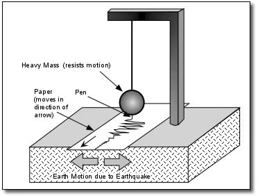
- The seismograph records the ground motion induced by seismic waves in a digital graphic format.
- The location, origin time, and magnitude (along with other properties) of earthquakes can be determined using seismograms from seismic monitoring stations.
Seismic Waves or Earthquake Waves
- Seismic waves are the vibrations or oscillations that travel through the Earth’s interior and across its surface in response to various sources of energy release, such as earthquakes, volcanic activity, or human-induced events.
- These waves carry energy and information about the Earth’s subsurface and are crucial for understanding the planet’s interior structure, seismic activity, and geological processes.
- These seismic waves travel as vibrations through the earth. The vibrations are recorded and measured by a device known as a seismometer.
- The seismometer generates a graph called a Seismograph that depicts these vibrations. These waves travel at different speeds through various materials.
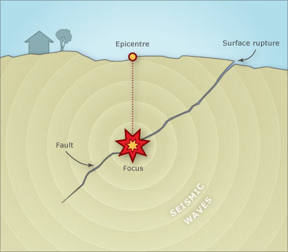
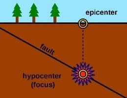
- Earthquake waves are caused by the rapid release of energy along a fault (a sharp rupture in the crustal layer).
- The force exerted on the rock layers along a fault causes them to move in opposite directions, but they are held in place by the frictional force exerted by the above rock strata.
- Over time, the pressure on the rock strata builds up and exceeds the frictional barrier, causing an abrupt movement that generates shockwaves (seismic waves) in all directions.
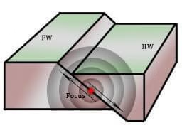
- Focus: The focus or hypocentre of an earthquake is the location where the energy is released.
- Epicenter: Epicenter refers to the place on the surface directly above the focus.
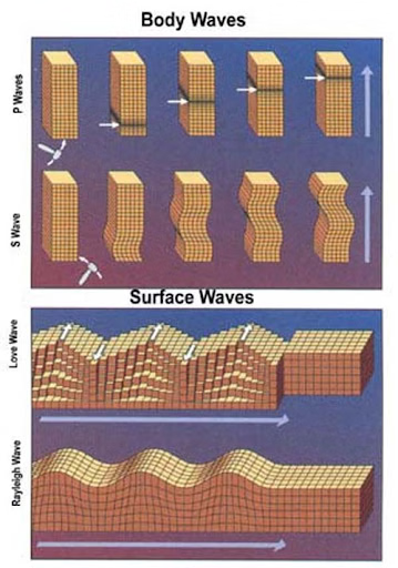
- There are two main types of Seismic Waves i.e. Body Waves and Surface Waves.
- Body waves are generated due to the release of energy at the focus and move in all directions traveling through the body of the earth.
- Surface waves are generated when body waves interact with the surface rocks. These waves move along the surface.

Body Waves
- Body waves are seismic waves that travel through the Earth’s interior.
- They are generated by the sudden release of energy from events such as earthquakes, volcanic eruptions, or even man-made explosions.
- Since they move through the Earth, they are instrumental in providing information about the Earth’s internal structure, including layer densities, thicknesses, and states of matter.
- By analyzing the travel times and paths of these waves, seismologists can infer a lot about the Earth’s interior structure and the properties of different layers.
- The variations in the speed and direction of body waves as they interact with different materials inside the Earth help scientists construct models of the Earth’s interior, including the identification of the core, mantle, and crust layers.
- There are two primary types of body waves: Primary Waves (P-waves) and Secondary Waves (S-waves)
Primary Waves (P-waves):
- They are the fastest among seismic waves and thus reach the recording instruments first.
- P-waves are compressional or longitudinal waves, which means the ground particles move in the direction of the wave propagation (similar to sound waves).
- They can travel through solid, liquid, and gaseous materials, which means they can pass through the Earth’s crust, mantle, outer core, and inner core.
- When they pass through the Earth’s surface, they can shake the ground in the direction of their movement, often feeling like a sudden jolt during an earthquake.
Secondary Waves (S-waves):
- They are slower than P-waves and arrive at the recording instruments after P-waves.
- S-waves are shear or transverse waves, which means the ground particles move perpendicular to the direction of wave propagation.
- They can only travel through solid materials. This characteristic of S-waves has provided critical evidence that the Earth’s outer core is liquid because S-waves do not pass through it.
- They cause more intense shaking than P-waves, moving the ground up and down and side-to-side, and are generally responsible for the damage and destruction during earthquakes.

Surface Waves (L Waves)
- When body waves interact with surface rocks, a new set of waves known as surface waves is created. These waves propagate across the earth’s surface.
- Surface waves are transverse waves in which particle motion is perpendicular to the propagation of the wave. As a result, they create crests and troughs in the material they pass through.
- Surface waves travel more slowly through Earth’s material and are generally lower in frequency than body waves.
- Deeper earthquakes produce weaker surface waves; shallow earthquakes produce stronger surface waves.
- Wave velocity changes as they travel through different densities of materials. The higher the velocity, the denser the material.
- When they come into contact with materials of varying densities, their direction changes as they reflect or refract.
- Because they cover the greatest distances of any seismic wave, they are also known as Long Period Waves or “L” waves.
- They are the last to reach the surface of the Earth and are the most powerful and destructive seismic waves.
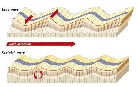
- Surface waves are classified into two types: Rayleigh waves and Love waves.
Rayleigh Waves:
- Rayleigh waves are another type of earthquake surface wave that causes both vertical and horizontal motion of particles.
- Rayleigh waves create an elliptical, rolling motion of particles. This motion includes both vertical and horizontal components.
- Rayleigh waves travel along the Earth’s surface and are typically slower than Love waves.
- Rayleigh waves can have larger amplitudes than body waves like P and S waves, contributing to ground displacement and shaking.
- The vertical motion of Rayleigh waves can cause uplift and subsidence of the ground, leading to ground cracks and surface deformations.
Love Waves:
- Love waves are a type of earthquake surface wave that causes horizontal, side-to-side motion of particles parallel to the Earth’s surface.
- Love waves cause particles to move in a horizontal, snake-like motion similar to the way a snake slithers across the ground.
- These waves propagate along the Earth’s surface, primarily within the uppermost layers of the crust.
- Love waves can have large amplitudes, contributing to significant ground shaking during earthquakes.
- The side-to-side motion of Love waves can cause structural damage to buildings, bridges, and other infrastructure, particularly if the structures are not well-designed to withstand horizontal shaking.
Emergence of Shadow Zone
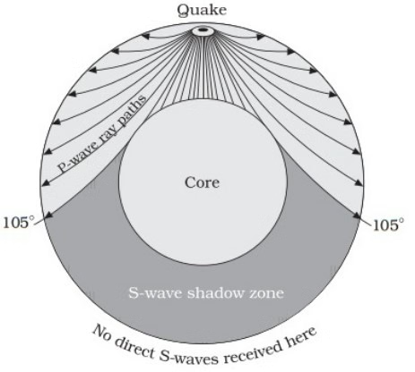
Shadow zone in seismology refers to an area on the Earth’s surface where seismographs cannot detect indirect seismic waves from an earthquake. The shadow zone is the area of the earth between 104 and 140 degrees from an earthquake that does not receive any direct P waves. The shadow zone occurs as a result of the liquid core completely stopping S waves and bending (refracting) P waves. Seismographs placed beyond 145 degrees from the epicentre, on the other hand, record the arrival of P-waves but not S-waves.
- A seismic shadow zone is an area on the Earth’s surface where certain types of seismic waves cannot be measured.
- The shadow zone arises due to the interactions of seismic waves with different layers inside the Earth.
- The existence and nature of these shadow zones provide indirect evidence for the composition and state (solid or liquid) of the Earth’s interior layers, especially the core.
- The shadow zone is the area of the earth between 104 and 140 degrees from an earthquake that does not receive any direct P waves.
- A seismograph, an instrument used to record the motion of the Earth’s surface caused by earthquake waves, does not show the complete behaviour of the earthquake at these locations.
- Shadow zones are classified into two types:
- S-wave Shadow Zones
- P-wave Shadow Zones
Background:
- Seismographs at remote locations record earthquake waves. There are, however, several specific areas where the waves are not reported. This is known as the “shadow zone.”
- The crust, mantle, inner core, and outer core are the distinct structures that make up the earth.
- The crust, mantle, and inner core are all usually solid, while the outer core is completely liquid.
- Richard Oldham, a geologist, was the first to demonstrate a liquid outer core in 1906.
- Oldham studied seismograms from several earthquakes and discovered that some seismic stations, notably those 120 degrees away from the earthquake’s hypocenter, failed to catch direct S waves.
- The sudden change in seismic velocities of the P waves and the absence of S waves at the core-mantle boundary was first detected by Beno Gutenberg in 1913.
Emergence of Shadow Zone:
- The investigation of several incidents demonstrates that each earthquake has a distinct shadow zone.
- It was discovered that seismographs placed within 105° of the epicentre recorded the arrival of both P and S-waves.
- Seismographs positioned beyond 145° from the epicentre, on the other hand, record the arrival of P-waves but not S-waves.
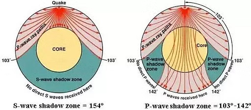
- As a result, the shadow zone for both types of waves was determined as a zone between 105° and 145° from the epicentre.
- S-waves are not received in the zone beyond 105°.
- S-wave shadow zones are significantly larger than P-wave shadow zones.
- The P-wave shadow zone appears as a band around the globe between 105° and 145° from the epicentre.
- The shadow zone of S-waves is not only greater in size, but it also covers somewhat more than 40% of the earth’s surface.
P-wave Shadow Zone:

P-wave Shadow zone
- P-waves get refracted (or bent) when they encounter the boundary between the mantle and the outer core due to a change in seismic wave speeds.
- This is due to Snell’s Law, which states that when a seismic wave collides with a boundary, it will either refract or reflect.
- The P waves refract in this scenario due to density variations, and their velocity is considerably reduced.
- This refraction creates a P-wave shadow zone between about 105° and 145° from the earthquake’s epicenter.
- Seismographs located within this shadow zone don’t record direct P-waves from the quake.
- P-waves eventually reappear beyond this shadow zone because some of the waves that pass through the core are refracted back out into the mantle.
S-wave Shadow Zone:
S-wave Shadow zone
- S-waves don’t travel through liquids.
- Since the outer core is believed to be in a molten or liquid state, S-waves that hit the outer core are absorbed and don’t pass through it.
- This results in a large shadow zone for S-waves, beginning at roughly 105° from the earthquake’s epicenter and extending across the rest of the planet.
- No direct S-waves are detected beyond this point.
- In the shadow zone, S waves that refract to P waves as they enter the outer core and then refract to an S wave as they leave the outer core can be identified.
Significance of Shadow Zone:
- The existence of shadow zones, notably S wave shadow zones, could have ramifications for volcano eruption mobility all over the world.
- Volcanoes become eruptive when their percentage melt falls below the rheological lockup (percent crystal fraction when a volcano is eruptive or not eruptive).
- Calculating a volcano’s percentage melt could aid in predictive modeling and assessing existing and future threats.
- A study conducted in 2021 on an actively erupting volcano, Mt. Etna in Italy, found that S-waves were absent in some areas and significantly attenuated in others, depending on where the receivers were positioned above the magma chamber.