

Chapter 1. Resources and Development
A resource includes everything in the environment that can satisfy human needs, provided it is technologically accessible, economically feasible and culturally acceptable, and its transformation depends on the interaction between nature, technology and institutions.
Resources are not free gifts of nature but are a result of human activities, as people use technology and institutions to convert natural materials into usable resources, making human beings themselves an essential part of resources.
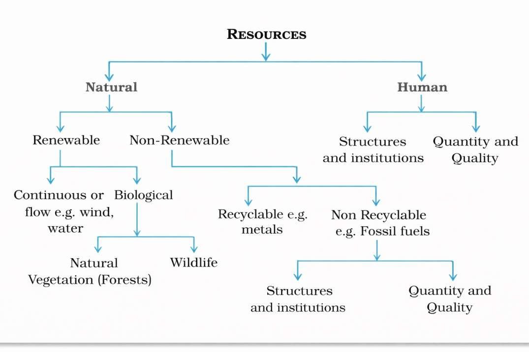
Resources can be classified on the basis of origin into biotic and abiotic, on exhaustibility into renewable and non-renewable, on ownership into individual, community, national and international, and on the status of development into potential, developed, stock and reserves.
Development of Resources
Resources are essential for human survival and quality of life, but the belief that they are free gifts of nature led to their indiscriminate use, resulting in depletion to satisfy the greed of a few and concentration of resources in limited hands, creating social divisions between rich and poor.
Overexploitation of resources has caused serious ecological crises such as global warming, ozone layer depletion, environmental pollution and land degradation, making equitable distribution of resources necessary for sustainable living and global peace.
Continued depletion of resources by a few individuals and countries threatens the future of the planet, highlighting the need for resource planning to ensure sustainable existence of all forms of life.
Sustainable development means achieving economic development without damaging the environment and without compromising the needs of future generations.
In 1992, the Rio de Janeiro Earth Summit brought together over 100 world leaders to address global environmental and socio-economic issues, resulting in agreements on climatic change, biological diversity and forest principles.
The summit adopted Agenda 21, a global action plan for sustainable development, aiming to combat environmental damage, poverty and disease through international cooperation, and encouraging every local government to formulate its own local Agenda 21.
Resource Planning
Planning is the most accepted method for the judicious use of resources, and it is especially important in a country like India due to the wide regional diversity in the availability of natural resources.
Some regions are rich in certain resources but lack others, while a few are self-sufficient and others face acute shortages of vital resources, highlighting the need for balanced utilisation.
States such as Jharkhand, Chhattisgarh and Madhya Pradesh are rich in minerals and coal, Arunachal Pradesh has abundant water resources but poor infrastructure, Rajasthan is well endowed with solar and wind energy but faces water scarcity, and Ladakh has rich cultural heritage but lacks water, infrastructure and key minerals.
These regional imbalances make balanced resource planning essential at national, state, regional and local levels to ensure equitable development.
Resource Planning in India:
Resource planning is a complex process involving identification and inventory of resources through surveying, mapping and qualitative and quantitative assessment, developing a planning structure with suitable technology, skills and institutions, and integrating resource development with overall national development plans.
India has made continuous efforts towards resource planning since the First Five Year Plan, yet mere availability of resources does not ensure development without appropriate technology and institutional support.
Several regions in India are resource rich but economically backward due to lack of technology, infrastructure and institutions, while some resource poor regions are economically developed because of better technology, skilled human resources and efficient institutions.
Historical experiences of colonisation show that technologically advanced nations exploited the resources of less developed regions, proving that resources contribute to development only when supported by technological progress and institutional change.
In India, development depends not only on resource availability but also on technology, quality of human resources and historical factors influencing regional growth.
Resource conservation is essential as irrational consumption and overuse lead to socio-economic and environmental problems, a concern strongly voiced by Gandhiji, who emphasised need-based use of resources and opposed mass production driven by greed.
At the global level, conservation ideas were promoted by the Club of Rome in 1968, reinforced by Schumacher’s Small is Beautiful in 1974, and firmly established by the Brundtland Commission Report (1987), which introduced the concept of sustainable development.
The importance of sustainable resource use was further highlighted at the Earth Summit, Rio de Janeiro (1992), strengthening global commitment towards conservation and sustainable development.
Land Resources
Land is a vital natural resource as it supports natural vegetation, wildlife, human settlements, economic activities, and transport and communication systems, but since it is finite in nature, its use requires careful and planned management.
India’s land is distributed among varied relief features such as mountains, plateaus, plains and islands, each having distinct importance and utility.
About 43 per cent of India’s land area consists of plains, which are most suitable for agriculture and industrial development.
Nearly 30 per cent of the land area is mountainous, ensuring perennial river flow, promoting tourism and maintaining ecological balance.
The plateau region covers around 27 per cent of the country and is rich in minerals, fossil fuels and forest resources, making it economically significant.
Land Utilisation
Land resources are utilised in multiple ways including forests, land not available for cultivation such as barren and wasteland or land used for non-agricultural purposes like buildings, roads and factories.
Other uncultivated land (excluding fallow land) includes permanent pastures and grazing lands, land under miscellaneous tree crops and groves, and culturable wasteland left uncultivated for more than five agricultural years.
Fallow land refers to land left without cultivation, which may be current fallow (up to one year) or other than current fallow (left uncultivated for one to five years).
Net sown area is the actual land area on which crops are grown and harvested during a year, while the total area sown more than once along with net sown area is called the gross cropped area.
Land Use Pattern in India
Land use is influenced by physical factors such as topography, climate and soil, and human factors like population density, technology, culture and traditions.
India’s total geographical area is 3.28 million sq km, but land-use data is available for only about 93 per cent due to incomplete reporting in most north-eastern states (except Assam) and unsurveyed areas of Jammu and Kashmir under foreign occupation.
The area under permanent pastures has declined, putting pressure on grazing land to support a large cattle population, while much of the land other than current fallow is of poor quality or costly to cultivate and is therefore farmed only once or twice in two to three years.
If such land is included, the net sown area accounts for about 54 per cent of the total reporting area, though its distribution varies widely, exceeding 80 per cent in Punjab and Haryana and remaining below 10 per cent in Arunachal Pradesh, Mizoram, Manipur and the Andaman and Nicobar Islands.
Forest cover in India is much lower than the desired 33 per cent recommended by the National Forest Policy (1952), affecting ecological balance and the livelihoods of millions dependent on forests.
Waste land includes rocky, arid and desert areas, while land under non-agricultural uses covers settlements, transport networks and industries, and continuous overuse of land without conservation has led to land degradation with serious social and environmental consequences.
Land Degradation and Conservation Measures
Land is shared by past, present and future generations, and about 95 per cent of basic needs such as food, shelter and clothing are derived from it, but human activities have accelerated land degradation and intensified the impact of natural forces.
Major human causes of land degradation include deforestation, overgrazing, mining and quarrying, with abandoned mining sites leaving deep scars and overburden, especially in Jharkhand, Chhattisgarh, Madhya Pradesh and Odisha.
Overgrazing has degraded land in Gujarat, Rajasthan, Madhya Pradesh and Maharashtra, while over-irrigation in Punjab, Haryana and western Uttar Pradesh has caused waterlogging, salinity and alkalinity of soils.
Mineral processing and industrial activities release dust and effluents that reduce water infiltration and pollute land and water, making industrial waste a major source of degradation in many regions.
Land degradation can be controlled through afforestation, regulated grazing, planting shelter belts, stabilising sand dunes with thorny bushes, proper management of wastelands, controlled mining, and safe treatment and disposal of industrial effluents and wastes.
Soil as a Resource
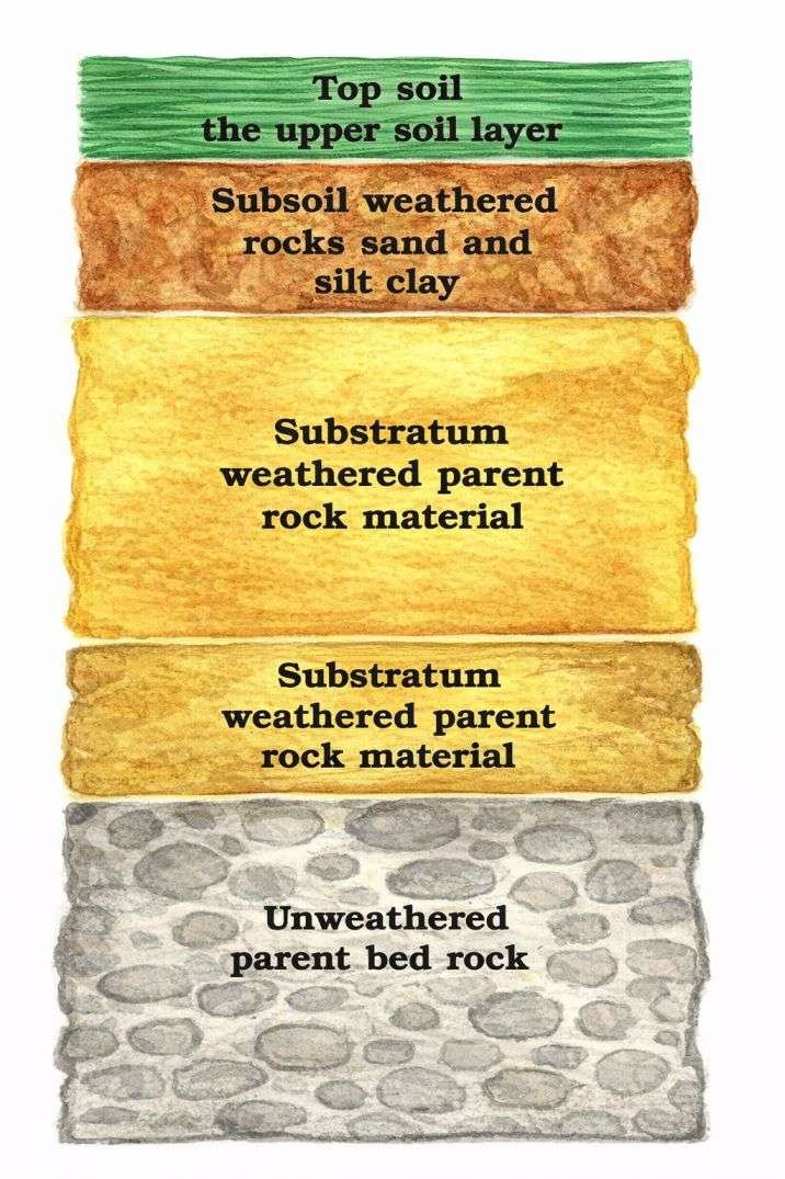
Soil is the most important renewable natural resource, acting as the medium for plant growth and supporting diverse living organisms, and it is a living system that takes millions of years to form even a few centimetres in depth.
Soil formation depends on factors such as relief, parent or bedrock, climate, vegetation, living organisms and time, along with natural forces like temperature variations, running water, wind, glaciers and the action of decomposers.
Both chemical and organic processes play a vital role in soil development, and soil contains organic matter in the form of humus as well as inorganic materials.
Based on formation factors, colour, thickness, texture, age and chemical and physical properties, the soils of India are classified into different types.
Classification of Soils:
India has diverse relief features, landforms, climatic conditions and vegetation types
These factors have resulted in the formation of different types of soils across the country
Alluvial Soils:
Most widespread and important soil of India
Covers the entire Northern Plains
Formed by deposition of sediments by the Indus, Ganga and Brahmaputra rivers
Also found in Rajasthan and Gujarat through a narrow belt
Present in eastern coastal plains, especially in the deltas of Mahanadi, Godavari, Krishna and Kaveri
Composed of sand, silt and clay in varying proportions
Soil particles are coarse near river valleys and piedmont plains such as Duars, Chos and Terai
Classified on the basis of age into:
Bangar (old alluvial soil) with more kankar nodules and less fertility
Khadar (new alluvial soil) with finer particles and higher fertility
Rich in potash, phosphoric acid and lime
Highly fertile and suitable for intensive agriculture
Major crops: rice, wheat, sugarcane, pulses and cereals
In dry areas, soils are alkaline but can be made productive with irrigation
Black Soil (Regur Soil):
Black in colour and also known as black cotton soil
Ideal for cotton cultivation
Formed from basaltic lava of the Deccan Trap
Influenced by climatic conditions and parent rock material
Found in Maharashtra, Saurashtra, Malwa Plateau, Madhya Pradesh and Chhattisgarh
Extends along the Godavari and Krishna valleys
Very fine and clayey in texture
High moisture retention capacity
Rich in calcium carbonate, magnesium, potash and lime
Deficient in phosphoric acid
Develops deep cracks during hot weather which help in aeration
Sticky when wet and difficult to plough
Red and Yellow Soils:
Developed on crystalline igneous rocks
Found in low rainfall areas of eastern and southern Deccan Plateau
Also present in Odisha, Chhattisgarh, southern parts of the middle Ganga Plain and along the Western Ghats piedmont zone
Red colour due to presence of iron in crystalline and metamorphic rocks
Yellow colour appears when iron is in hydrated form
Generally less fertile but productive with proper management
Laterite Soils:
Derived from the Latin word ‘later’ meaning brick
Develops under tropical and subtropical climate with alternating wet and dry seasons
Formed due to intense leaching caused by heavy rainfall
Mostly deep to very deep in nature
Acidic with pH less than 6.0
Deficient in plant nutrients
Found in southern states, Western Ghats of Maharashtra, Odisha, parts of West Bengal and North-East India
Rich in humus under forest cover but poor under sparse vegetation
Prone to erosion and degradation
Suitable for tea and coffee cultivation after soil conservation
Red laterite soils support cashew nut cultivation
Arid Soils:
Range in colour from red to brown
Sandy in texture and saline in nature
High salt content in some areas
Lack humus and moisture due to dry climate and high evaporation
Lower layers contain kankar (calcium carbonate)
Kankar layer restricts water infiltration
Can be made cultivable with proper irrigation
Found mainly in western Rajasthan
Forest Soils:
Found in hilly and mountainous regions with sufficient rainfall
Texture varies according to relief and altitude
Loamy and silty in valley sides
Coarse-grained on upper slopes
In Himalayan snow-covered areas, soils are acidic with low humus content
Fertile soils found in lower valleys, river terraces and alluvial fans
Soil Erosion and Soil Conservation:
Soil erosion is the removal and washing away of the soil cover, and although soil formation and erosion usually remain balanced, this balance is often disturbed by human activities such as deforestation, overgrazing, mining and construction, as well as natural agents like wind, water and glaciers.
Running water causes gully erosion by cutting deep channels in clayey soils, making land unfit for cultivation and known as bad land, called ravines in the Chambal basin, while sheet erosion occurs when water flows over slopes and removes the fertile topsoil.
Wind erosion takes place when loose soil is blown away from flat or sloping land, and improper farming practices such as ploughing up and down slopes further accelerate soil loss.
Soil erosion can be reduced through contour ploughing along slope lines to slow water flow, terrace cultivation on hill slopes as practised in the western and central Himalayas, strip cropping with grass strips to break wind force, and planting shelter belts of trees to stabilise sand dunes and reduce desert expansion in western India.