
Fundamental Concepts of Geography
Nature of Geography:
Geography is essentially an earth science that studies the earth and its environs as the home of humankind. It examines the spatial relationships and physical conditions that influence human life.
Scope of Physical Geography:
Physical geography focuses specifically on the study of the physical environment in which humans live. This includes the conditions of the earth’s surface, the atmosphere surrounding the earth, and the interior of the earth. All these factors collectively shape the well-being of mankind and form a core part of physical geography.
Evolution of Geomorphological Thoughts
Post-1950 Developments:
After 1950, geomorphology underwent significant changes. The Davisian model of cyclic landform development was rejected, and new approaches began to emerge.
Rise of Quantitative and Process-Based Approaches:
This period saw the introduction of quantitative methods in geomorphological studies. A major conceptual shift was the postulation of the dynamic equilibrium theory of landscape development, which emphasized time-independent landform evolution. Greater focus was placed on process geomorphology, prioritizing the study of ongoing physical processes that shape the landscape.
The Earth and Its Relation in the Solar System
Earth as a Unique Planet:
Earth, the third planet from the sun, is the only known place in the universe confirmed to support life. With a radius of 3,959 miles, it is the fifth-largest planet in the solar system and the only one known to have liquid water on its surface.
Naming and Cultural Significance:
Unlike other planets named after Greek or Roman deities, Earth draws its name from the Germanic word meaning “the ground.” This term has been used for at least a thousand years across various cultures.
Earth’s Orbit and Motion:
Earth completes one orbit around the sun every 365.25 days. Since the calendar year has 365 days, an additional leap day is added every four years. The planet travels through space at an average velocity of 18.5 miles per second and remains about 93 million miles from the sun—defined as one astronomical unit (AU), a standard cosmic measurement.
Rotation, Tilt, and Seasons:
Earth rotates on its axis every 23.9 hours, creating day and night. Its axis is tilted 23.4 degrees relative to its orbital plane, resulting in seasonal variations. The hemisphere tilted toward the sun experiences summer, while the opposite hemisphere experiences winter. During the equinoxes, both hemispheres receive equal illumination.
Earth’s Structure and Physical Features
Formation and Internal Layers:
Earth formed about 4.5 billion years ago from the gaseous, dusty disk surrounding the young sun. Over time, its interior differentiated into four layers:
- Inner Core: A solid sphere of iron and nickel, 759 miles wide, with temperatures reaching 9,800°F.
- Outer Core: A 1,400-mile-thick layer of molten iron and nickel.
- Mantle: A 1,800-mile-thick region of viscous molten rock.
- Crust: The outermost layer, with continental crust averaging 19 miles thick and oceanic crust about three miles thick and denser.
Landforms and Earth’s Surface:
Earth shares features such as mountains, valleys, and volcanoes with Venus and Mars. However, nearly 70 percent of Earth’s surface is covered by oceans averaging 2.5 miles deep. These oceans contain 97 percent of Earth’s volcanoes and host the mid-ocean ridge, over 40,000 miles long.
Plate Tectonics and Geological Activity:
Earth’s crust and upper mantle are divided into tectonic plates that move slowly. Their interactions—colliding, separating, or sliding past each other—produce major geological phenomena. Earthquakes occur when plates snag and slip, volcanoes often form where oceanic crust subducts beneath continental crust, and massive mountain ranges like the Himalayas arise where continental plates converge.
Earth’s Protective Fields and Atmospheric Composition
Composition and Function of the Atmosphere:
Earth’s atmosphere consists of 78% nitrogen, 21% oxygen, and 1% other gases such as carbon dioxide, argon, and water vapor. Acting as a greenhouse, it absorbs and retains heat, keeping Earth’s average surface temperature near 57°F instead of zero.
Human Influence on Atmospheric Conditions:
Over the past two centuries, increased greenhouse gas emissions have raised Earth’s temperature by 1.8°F, influencing global weather patterns.
Protective Role of the Atmosphere:
The atmosphere burns up many incoming meteorites, shielding the surface. Ozone within the atmosphere blocks harmful ultraviolet radiation. Despite its importance, 90% of the atmosphere lies within just 10 miles of the surface.
Latitude
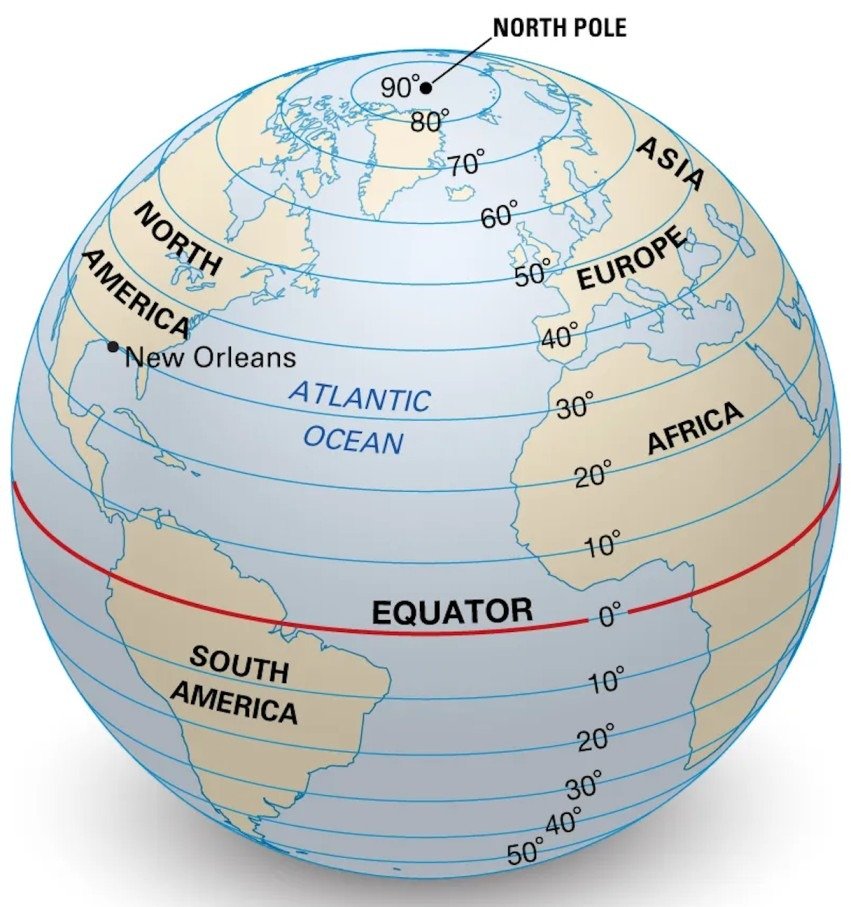
Definition and Measurement:
Lines of latitude run east–west across maps, indicating the north–south position of points on Earth. Latitude begins at 0° at the equator and extends to 90° at both the North and South Poles. The Northern Hemisphere lies above the equator, and the Southern Hemisphere lies below it.
Parallels and Their Significance:
Latitudes are called parallels, totaling 180 degrees. Each degree spans roughly 69 miles (110 kilometers). The five major parallels, from north to south, include:
- Arctic Circle
- Tropic of Cancer
- Equator
- Tropic of Capricorn
- Antarctic Circle
Representation on Maps:
On maps oriented with north at the top, latitudes appear as horizontal lines running across the surface.
Longitude
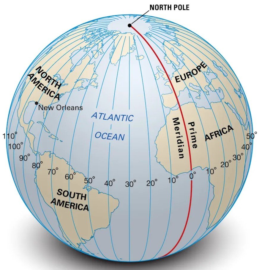
Definition and Orientation of Longitude:
Longitude refers to the north–south lines on a map or globe that indicate the east–west position of a point on Earth. These lines, known as meridians, extend from the North Pole to the South Pole and intersect the equator at right angles. Their primary function is to determine how far east or west a location lies from a reference line.
Degrees of Longitude and the Prime Meridian:
There are 360 degrees of longitude in total. The 0-degree longitude line is called the Prime Meridian, an internationally recognized reference line that divides the Earth into two equal halves:
- The Eastern Hemisphere, extending up to 180° east.
- The Western Hemisphere, extending up to 180° west.
This division allows for a systematic global coordinate framework.
Variation in Distance Between Longitudes:
The spacing between longitude lines varies with latitude. At the equator, this distance is similar to that between latitude degrees—approximately 69 miles. However, as one moves toward the poles, this distance decreases.
Changes in Distance with Increasing Latitude:
At 45 degrees north or south of the equator, the distance between two meridians is about 49 miles (79 km). This narrowing occurs because meridians converge as they move away from the equator.
Convergence of Meridians at the Poles:
The distance between longitude lines eventually becomes zero at both poles. At these points, all meridians meet, making the poles unique locations where longitude cannot be used to determine east–west position.