Land Capability
- Land capability survey was devised by the Commonwealth Scientific and Industrial research Organisation (CSIRO) for demarcation of land capability regions of Australia. Subsequently the capability survey was widely applied in European and AngloAmerican countries and in some of the Third World Countries.
- Land capability may be defined as the ability of the land surface to support natural plant growth/ wildlife habitat or artificial crop growth/ human habitat. Thus, it indicates the type of land use [viz., human habitation, agriculture, pastures, forests, wildlife habitat, etc.] that is suitable over a particular type of land.
- Land capability survey helps in ascertaining the usefulness of land, its utility for agriculture, forest, industry, tourism, and other land use purpose.
- For the delineation of land capability regions, only physical parameters are taken into consideration. The demarcation of these regions in fact is on the basis of texture, structure of soil, terrain, slope, run-off, temperature, and precipitation. Thus, in the land capability survey, there is a heavy reliance on the results of soil survey in pedological conditions.
- In general each soil group has its own physical and chemical properties. These properties determine the land capability and land suitability. For example, the regur soil is good for the cultivation of cotton, sugarcane and citrus fruits, while the alluvial soil is utilised for wheat, rice, maize, sugarcane, pulses, and oilseeds.
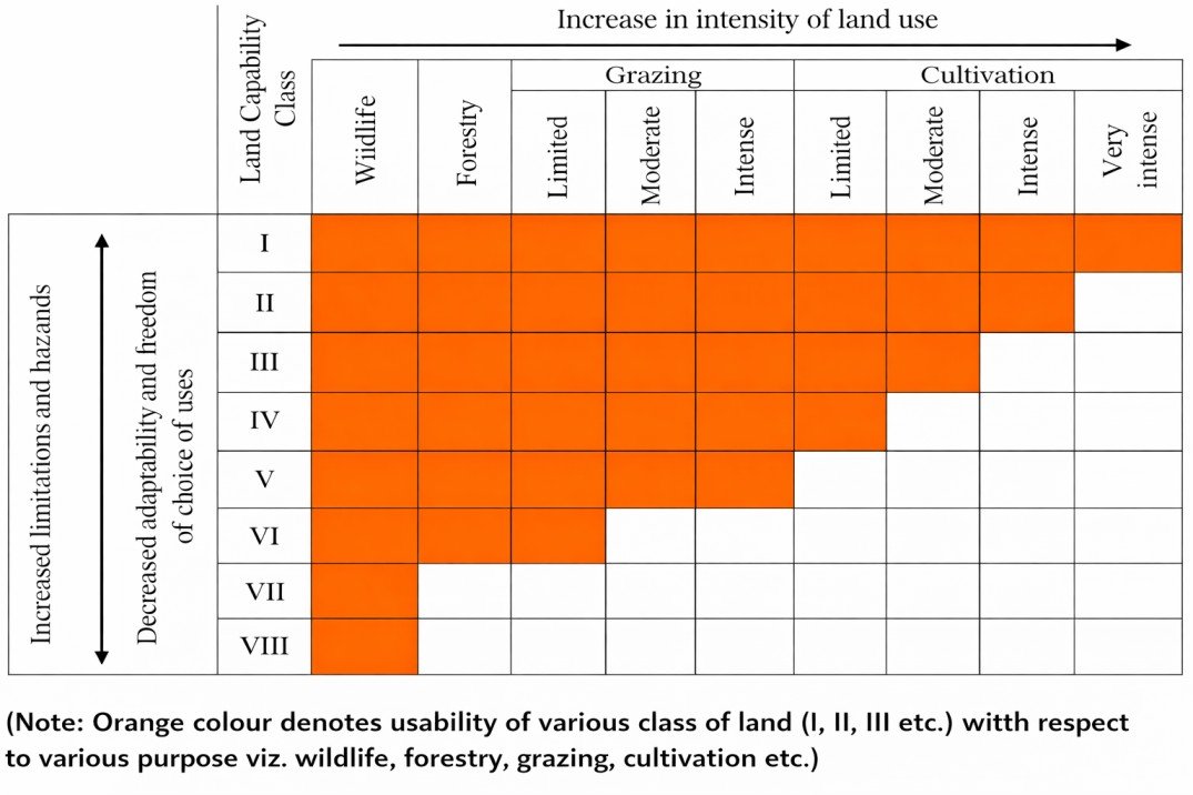
- In India, the basic objective of the soil survey was to achieve the land capability classification. The All India Soil and land Use Survey Organization attempted the land capability survey in 1960 which identified eight land use capability classes.
Land Suitable For Cultivation
- Class I: Very good arable land with no specific difficulty in farming. It is nearly levelled, well drained, easily worked soil. These soils are very productive.
- Class II: Good cultivation land which needs protection from erosion or floods, drainage improvement and conservation of irrigation water, intensive drainage, and protection from floods.
- Class III: Moderately good cultivation land where special attention has to be paid to erosion control, conservation of irrigation water, intensive drainage, and protection from floods.
- Class IV: Fairly goof land suited for occasional and limited cultivation. It needs intensive erosion control, intensive drainage and very intensive treatment to overcome the soil limitations.