
INTRODUCTION
- India is a land of great diversity and potential, with a rich culture and civilization as old as humanity.
- Geographically, India is located in South Asia, featuring the Himalayas in the north, permanently snow-covered.
- The Indian Ocean borders India to the south.
- The country includes vast areas of diverse landmasses, including the fertile Great Plains of India and the Thar Desert to the west.
- The eastern part of the plains features the delta of the Ganga-Brahmaputra Rivers.
- South of the plains is Peninsular India, with uneven plateaus and rivers flowing in different directions.
- The eastern coastal plain is washed by the Bay of Bengal, while the western coastal plains are narrow.
- India has a typical monsoonal climate with significant climatic variation from dry continental to humid littorals.
- India’s vastness and diversity have earned it the term “sub-continent,” though some Indian geographers prefer not to use this term.
- India displays vast differences in religion, customs, ideas, dress, and food habits, yet maintains unity in diversity.
- The country has a history of immigration and cultural integration, contributing to a unique Indian culture.
- Physical, climatic, soil, animal life, agricultural, mineral, and industrial diversities shape India’s social and cultural landscape.
- India is a country of unity in diversity, with manifold physical, cultural, and economic contrasts.
- Despite natural contrasts and changing socio-economic and political patterns, India projects itself as a single territorial unit.
- The Great Plains have played a significant role in developing Hindu culture, a fusion of Dravidian and Aryan cultures.
- National integration is reflected in the location of four holy places: Badri-Kedarnath (north), Puri (east), Rameshwaram (south), and Dwarka (west), representing the country’s religious cardinal points.
Nomenclature
- India has been named variously as India, Hindustan, Bharat, and Aryavarta.
- The word “India” traces its origin to Greek literature, referring to the land of the people near the Indus River.
- Persians called the river Sindhu, and the people living near it were called Hindu.
- Persians pronounced ‘S’ as ‘H,’ thus the land east of Sindhu became Hindustan.
- The name ‘Bharat’ has geographical and historical significance, developed after Bharat, a sovereign King.
- Bharat is mentioned in the Rigveda as a leader of a powerful Aryan tribe.
- The Bhagavata Purana calls him Adhirat and Samarat, meaning King of Kings, who accelerated Aryanisation.
- Bharat symbolizes Aryanised India, where Aryan culture developed and flourished.
- Currently, “India” and “Bharat” are mostly used, though “Hindustan” is also common.
LOCATION
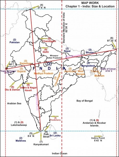
- India is the seventh largest country in the world.
- Area: 32,87,782 sq. km (2.4% of the total surface area of the world).
- North-south distance: approximately 3214 km.
- East-west extent: about 2933 km.
- Entirely in the Northern Hemisphere.
- Latitude: 8°4′ N to 37°18′ N.
- Tropic of Cancer divides India into almost two equal halves.
- Southernmost point of the mainland: Kanyakumari.
- Andaman and Nicobar Islands lie in the Bay of Bengal (6°N to 14°N), volcanic origin.
- Lakshadweep Islands in the Arabian Sea, coral origin.
- Southernmost point: Indira Point in Nicobar Islands.
- Longitudes: 68°7′ E to 97°25′ E.
- Standard Meridian: 82°30′ E longitude, passes through Mirzapur near Allahabad.
- Longitudinal difference: 30°, causing a 2-hour time difference between Saurashtra and Arunachal Pradesh.
- Latitudinal difference affects the length of day between Kerala and Ladakh.
- India has a wide impact on rainfall, temperature, and vegetation due to its extent.
- Rich in natural resources, many still unexploited.
- Known for minerals, forests, groundwater, and fertile land.
- Leading agricultural country, but behind in crop productivity compared to advanced countries.
- Self-dependent in food production, capable of meeting food requirements of the growing population.
- Second largest population in the world, potential for huge manpower resource.
SITE AND SITUATION
- India’s strategic and transport importance is significant due to its central location in the Eastern Hemisphere, commanding trade routes in all directions.
- It stands at the head of the Indian Ocean and is a key player among littoral states, having a long coastline on the ocean.
- The Indian Ocean is named after India, highlighting its historical prominence.
- Trans-Indian Ocean routes connecting Europe and Asia pass by India’s shores.
- Many air routes between Europe, West Asia, Africa, and East Asia also pass through India.
- India is in direct contact with East African and Middle Eastern countries.
- The Suez Canal has brought Southern Europe and North Africa closer to India.
- The Malacca Strait connects India to Singapore, Vietnam, Cambodia, Hong Kong, Macau, Malaysia, and Indonesia.
- Historically, Indian traders and sailors had extensive trade relations with Asian and Western Asian countries, trading spices, precious stones, gold, and textiles.
- South Indian rulers like the Cholas, Pandyas, and Pallavas established colonies in Eastern Asia, influencing local cultures.
- Evidence of Indian culture exists in Thailand, Indonesia, and other regions, including temples with inscriptions from the Ramayana.
- India’s strategic location attracted European colonizers like France, Portugal, Britain, and Holland.
- The British established the East India Company and eventually controlled India for nearly three centuries.
- India has a prominent position among SAARC countries and plays a crucial role in social and economic leadership in Asia.
- India is the birthplace of major religions like Buddhism, Jainism, and Hinduism, spreading these cultures to South and East Asia.
- India’s land routes facilitated ancient cultural exchanges, with invasions and migrations enriching its cultural diversity.
- Officially the Republic of India, it consists of 29 states and 7 union territories, with Telangana being the newest state formed in 2014.
- Rajasthan is the largest state by area, while Goa is the smallest.
- As of the 2011 census, India’s population was over 1.21 billion, with Uttar Pradesh being the most populous state.
- Bihar is the most densely populated state, while Arunachal Pradesh is the least densely populated.
- Kerala has the highest literacy rate and the highest female-to-male ratio.
- Maharashtra, Bihar, West Bengal, and Andhra Pradesh are among the most populous states.
- Among union territories, Delhi is the most populous and densely populated.
- India had 7933 towns and 640,930 villages in 2011, with urban population comprising 31.2% of the total.
- Uttar Pradesh has the largest rural population, while Maharashtra has the highest urban population.
- The population growth rate was 17.7% from 2001-2011, with urban growth at 31.8%.
- The child population (0-6 years) was 164.5 million, with a decline in the child sex ratio.
- The scheduled caste population was 201.4 million, with Punjab having the highest proportion.
- The scheduled tribe population was 104.3 million, with Lakshadweep having the highest proportion.
- India had 763.5 million literates in 2011, with male literacy at 80.9% and female literacy at 64.6%.
- The total workforce was 481.7 million, with 55% engaged in agriculture and the rest in non-agricultural activities.
INDIA & INTERNATIONAL BOUNDARIES & COUNTRIES (FRONTIERS)
- India is encompassed by the Himalayas in the north, north-west, and north-east, the Indian Ocean in the south, the Marshy Rann of Kutch, the Thar Desert of Rajasthan, and the fertile plain of Punjab-Haryana in the west.
- India has both land and water frontiers.
- Land Frontiers: India shares a 15,200 km long land frontier with Pakistan in the west and north-west, Afghanistan in the northwest, China, Nepal, and Bhutan in the north, and Bangladesh and Myanmar in the east.
- India’s longest border is with Bangladesh (4096 km), and the shortest is with Afghanistan (80 km).
- Border with China: India shares a 3917 km long border with China, which is one-fourth of the total land border of the country. Five Indian states touch the border with China: Jammu and Kashmir, Himachal Pradesh, Uttarakhand, Sikkim, and Arunachal Pradesh.
- This boundary is divided into three sectors: the Western Sector (2152 km), the Middle Sector (625 km), and the Eastern Sector (1140 km).
- The Western Sector separates Jammu and Kashmir from the Xinjiang province of China. The Middle Sector runs along the watershed from Ladakh to Nepal, involving Himachal Pradesh and Uttarakhand. The Eastern Sector runs from Sikkim to Arunachal Pradesh, following the McMahon Line.
- India-Nepal Boundary: India shares a 1752 km long boundary with Nepal, touching the states of Uttarakhand, Uttar Pradesh, Bihar, Sikkim, and West Bengal.
- India-Bhutan Boundary: It is 587 km long, touching Sikkim, Arunachal Pradesh, West Bengal, and Assam.
- India-Bangladesh Boundary: India has a 4096 km long border with Bangladesh, touching West Bengal, Assam, Meghalaya, Tripura, and Mizoram. The boundary is determined under the Radcliffe Award.
- India-Myanmar Boundary: This boundary is 1458 km long, touching Arunachal Pradesh, Nagaland, Manipur, and Mizoram.
- India-Pakistan Boundary: This boundary resulted from the partition of 1947 and runs through varied relief features, starting from the Rann of Kutch in Gujarat to the Karakoram Range. It is known as the Radcliffe Line.
- The boundary along Jammu and Kashmir has been a matter of dispute, with India legally incorporating the state in 1947. The ceasefire line established in 1949 is now the Line of Control. Significant areas remain under illegal occupation by Pakistan and China.
- The Siachen Glacier, Sir Creek, and the Nubra River are notable geographic features on this boundary.
- India-Afghanistan Border: India shares an 80 km long mountainous border with Afghanistan in the Hindukush region.
- Water Frontiers: India has a 7517 km long coastline, with 6100 km on the mainland and 1417 km added by the Andaman and Nicobar Islands and Lakshadweep Islands.
- The Indian Ocean, including the Arabian Sea and Bay of Bengal, has significant strategic importance for India, facilitating trade and spiritual contacts historically.
- The Indian Ocean is rich in natural resources and holds great geopolitical significance, attracting interest from superpowers like the USA, China, and Russia.
- India-Sri Lanka Boundary: The Palk Strait separates India from Sri Lanka. Dhanush Kodi in Tamil Nadu is 32 km away from Talaimanar in Sri Lanka, connected by Adam’s Bridge. This proximity has led to significant Tamilian migration and cultural influence in northern and northeastern Sri Lanka.

CONCLUSION
- India projects itself as a single territorial unit despite natural contrasts and changing socio-economic and political patterns.
- India is a country of many religions, with people worshipping different deities.
- Hindus believe in the doctrines of Karma, Dharma, rebirth, immortality of the soul, renunciation, and Moksha.
- Hindus are free to visit any pilgrimage without restriction.
- Hinduism is a way of life rather than a monolithic culture.
- The Great Plains play a unifying role, linking diverse structural units and contributing to India’s unity.
- The Ganga is regarded as ‘Mother Ganga,’ providing perennial vitality to society and acting as the strongest cultural bond.
- The cultural heritage of the Ganga is pervasive, leading to the ‘Gangaisation’ of Indian culture, with rivers like the Kaveri and Godavari reflecting its influence.
- Cultural unity in India is strong and resilient against various barriers, including foreign influences.
- India is a multi-lingual nation, with languages serving as a bridge in social and cultural interactions.
- Texts like the Ramayana, Mahabharata, Vedas, Puranas, and Upanishads continue to influence themes in music, dance, and daily life.
- Sages and prophets like Buddha, Kabir, Tulsi, Shankaracharya, and Ramanujam have paid homage to various cultural and religious places.
- Forests, once plentiful, were the abode of forest culture and shelters for great thinkers, saints, meditators, and yogis.
- Muslim and British rulers failed to disrupt India’s cultural unity.
- The British laid the foundation for industrial development, leading to urban and industrial culture.
- India’s political unity is strengthened by its strong cultural base.
- India is committed to becoming a strong, powerful, and prosperous country.