
Introduction
Urban land use literally refers to what takes up the physical space of a town or city. The main urban land uses are:
- Residential
- Industrial
- Commercial and administrative
- Infrastructure (including transport)
- Open space (including planned open space like parks, and derelict space)
Urban land use is generally described as the land use at ground level. This is typically what is shown on maps. It’s important to recognise that as well as a horizontal ground level variation in land use, there can also be a vertical variation. For example, there might be a residential tower block above a shopping mall. This vertical variation is greatest in the Central Business District (see the separate page on economic activity in the CBD).
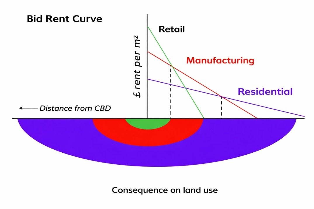
Variations in urban land use are shown using geographical models, and can be explained by theories including ‘bid rent’. The theory of bid rent is explained elsewhere on this site.
In plain-speak, urban structure is an understanding of which parts of a city are located where are all the offices located together, are they homes located according to economic status and so on. Urban planners, sociologists, economists and geographers broadly agree on three structural models:
- Concentric Ring Model
- Sectoral Model
- Multiple Nuclei Model
The Concentric Ring Model: Burgess
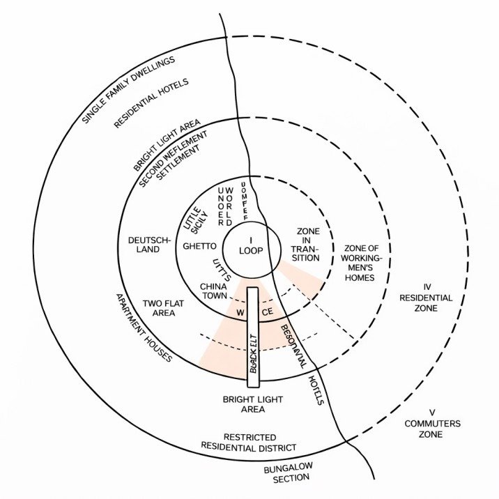
- The Burgess Model was developed by Ernest Burgess in 1925. He identified a series of concentric rings coming out from the centre of the city which correspond to different types of land use. In the centre was the Central Business District; followed by an inner city area known as the transition zone, with light manufacturing; then a series of residential zones gradually becoming wealthier towards the edge of the city.
- Burgess’s original model can be seen below. It was entirely based on Chicago. The sloping line through the centre shows the shore of Lake Michigan. To the left of this line Burgess labelled the reality of Chicago with names and types of places; to the right, he identified the academic terms he gives to each zone.
The model is useful because it shows a heavily simplified version of reality that could be applied to many cities. It doesn’t actually explain why these zones are in those locations, but it is the basis for theories that do: the main one is bid-rent, discussed elsewhere on this site. Some other explanations that follow from the Burgess model are:
- The CBD is in the middle because it is the central location, and therefore easiest to get to. This encourages businesses to be located there because they can access the most customers.
- Low class residential (the ‘zone of working-men’s homes’) is near the factory/transition zone because it is an undesirable location (polluted and congested), and because these people must walk or use public transport to get to work in the factories
- People on low incomes cannot afford large houses, so these areas become densely populated; the population density on the outskirts is lower as the house size is larger
- High class residential is around the outside because these people can afford the private transport to get to the city centre quickly and conveniently
When a city has a high-density Central Business District surrounded by decreasing zones of development density, the urban agglomeration is said to be distributed as concentric rings. This form of urban development is seen in cities like New York or Chicago or Mumbai, to a lesser extent.
The CBD usually has, as it name implies, most of the business space in the urban area along with some residential areas. The cost of space is usually very high due to the limited space and the high demand. However, while up-market residential and business space is very expensive, many inner cities of this type also have run-down areas inhabited by the less well-off among its citizens. These could be the older parts of the city centre where the dilapidated buildings find few high-income takers or where the transportation network is poorly developed. These areas usually spiral downwards unless revived with comprehensive redevelopment schemes.
Immediately outside the CBD lie mid-rise districts with a predominantly residential nature. The residents are mostly middle-class and this middle ring is usually well linked to the city centre through public transport. Finally, there are the suburbs which lie farthest for the centre of the ring city. These are almost exclusively low-rise, usually detached houses which are inhabited by the upper and middle classes. The suburbia, familiar to us in innumerable movies, is far removed from the hustle and bustle of the city centre but necessitates a long in-and-out trip Everyday, the famous “commute”.
The concentric ring model may sound very convenient, and indeed, anyone not too kindly disposed towards social equality may see it as a great way to keep the masses down. Other than the fact that it creates and encourages social inequity, the concentric ring structure also imposes other difficulties like inefficiencies in transport. That may sound counter-intuitive, after all isn’t simple for everyone to travel in and out of a single focal point? But, what if the Airport is on the other side of the CBD? It means either a long, frustrating trip through the chaos of the inner city or a even longer detour along a ring road, if one fortunately exists.
The congestion at the city centre usually means very tall buildings and expensive real estate. Even if an alternate or parallel CBD was proposed, organisations may be reluctant to leave the existing centre of activity and such a shift would also require a massive change in the supporting infrastructure which would be focused on the existing CBD.
Burgess identified a system of five concentric zones, each characterized by a particular type of land use:
Zone I (Central Business District-CBD): CBD occupies the central place and it is the focus of city’s commercial, social and civic life. This part is most readily accessible part of the city as all routes radiate here. The heart of this zone is known as the downtown. It contains departmental stores, smart shop, office buildings, financial institutions, banks, insurance offices, real estate offices, hotels, restaurants, wholesale trade, theatres, recreation places and headquarters of economic, social, civic and political organizations. The land value and rent of space are very high in the CBD.
Zone II (Zone in Transition): This zone surrounds the CBD and it is the zone of residential deterioration. There is invasion of business in this area which led to a decline in residential desirability. Some slums may also develop in this area. There may be some light industries in the inner part of this zone. The owners of property in this zone are not interested in improving the quality of buildings. This area is occupied by lower income groups. They live close to the place of work as they cannot afford high cost of transport.
Zone III (Zone of Independent Workmen’s Home): This zone is made up largely of the homes of factory workers and labourers and these are the people who often moved out of the zone II (zone of transition). In India, generally, this area has planned flats. The density and occupancy of this zone is always high.
Zone IV (Zone of Better Residence): In this zone the majority of the middle and upper-middle class people reside. Small businessmen, professional people, better paid government employees and salesmen reside in this zone. This area is dominated by single families.
Zone V (Commuter’s Zone): Beyond the city proper are located a small number of small towns which are mostly dormitory towns in that most of the people living here commute to the city every day for work. Most of the people living here work in the CBD. Here are large spacious houses usually having their own lawns etc. and are built at some distance from each other. The cost of land is comparatively low.
As stated above, each of the city zone, according to Burgess, has a tendency to expand outward.
Criticism:
- The Burgess’ model suggests a circular shape of the CBD. The CBDs are generally either square, rectangular or linear and not necessarily circular in shape.
- There is overemphasis on commerce and trade activity and a complete neglect of the industrial land use.
- The outward expansion of the Zone I into Zone III has not been explained. In fact, how the lower income group people can encroach the outer space of Zone III occupied by rich people
- The effect of major transport has been ignored. People prefer to stay close to the roads. Consequently, the space along the roads has high valuation and high rent value.
- The topographical factors have also been ignored. Concentric zones are not possible in the areas of undulating topography and the cities located near lakes, rivers and other water bodies.