1.The premise that present-day processes have been operating throughout geological time is the principle of (SEPT 2013)
(1) Continental drift
(2) Uniformitarianism
(3) Earth Systems
(4) Plate Tectonics
Correct Answer (2):
The principle of uniformitarianism states that geological processes such as erosion, sedimentation, and volcanic activity have been consistent throughout Earth’s history. Popularized by James Hutton in the 18th century and Charles Lyell in the 19th century, it is summarized by the well-known statement “the present is the key to the past.” This principle helped replace earlier catastrophist interpretations and became the basic foundation of modern historical geology.
Other option
Continental Drift: Proposed by Alfred Wegener, it suggests that continents have moved across Earth’s surface over time and is now incorporated into the broader framework of plate tectonics.
Earth Systems: Studies Earth’s components (geosphere, hydrosphere, atmosphere, biosphere) as interacting systems.
Plate Tectonics: Explains the movement of Earth’s lithospheric plates, accounting for earthquakes, volcanoes and mountain building.
2. The concept of peneplain is associated with (SEPT 2013)
(1) WM Davis
(2) W Penck
(3) A Staler
(4) E Huntington
Correct Answer (1):
The concept of a peneplain is primarily associated with the American geographer and geologist William Morris Davis(W. M. Davis). He introduced the idea within his Cycle of Erosion theory. The peneplain represents the final stage of the Normal Cycle of Erosion, produced mainly by river and rain erosion, which gradually reduce a high relief landmass almost to base level (near sea level). The surface is generally low-lying and is marked by isolated residual hills of more resistant rock, called monadnocks, which often show a convex–concave profile. Although later geomorphologists criticised Davis’s model for being over-idealised and time-dependent, it remains one of the most influential classical models in geomorphology.
Other option
W. Pink: Not associated with the peneplain concept.
A. Staler – Arthur Strahler: Known for quantitative and process-based geomorphology, not for the peneplain concept.
E. Huntington – Ellsworth Huntington: Known mainly for climatic determinism, not for erosion cycles.
3. Match the List I with List II and select the correct answer by using the codes given below (SEPT 2013)
| List-I (Agents of erosion) | List-II (Landforms) |
|---|---|
| A. River | I. Dolines |
| B. Glacier | II. Inselberg |
| C. Wind | III. Moraines |
| D. Underground water | IV. Levees |
Codes
(1) A-IV, B-III, C-II, D-I
(2) A-I, B-II, C-IV, D-III
(3) A-II, B-III, C-I, D-IV
(4) A-III, B-IV, C-II, D-I
Correct Answer (1):
The correct matching is A-IV, B-III, C-II, D-I.
River – Levees: Levees are natural embankments formed by the deposition of sediments during floods. The coarser and heavier materials are deposited close to the river channel, forming raised ridges, while finer sediments are laid farther away, creating gentle slopes.
Glacier – Moraines: Moraines are accumulations of unsorted debris (till) carried and deposited by glaciers. They occur as lateral, terminal, medial and ground moraines, depending on their position in relation to the glacier.
Wind – Inselberg: Inselbergs are isolated steep-sided residual hills rising abruptly from plains. They form because hard and resistant rock masses remain after the surrounding softer rocks are removed mainly by prolonged weathering and erosion, including aeolian action.
Underground water – Dolines: Dolines (sinkholes) are closed depressions formed in limestone regions due to solution of limestone by percolating groundwater or by the collapse of roofs of underground cavities, and are characteristic features of karst topography.
4. Match List I with List II and select the correct answer from the codes given below (SEPT 2013)
| List-I (Landform) | List-II (Agents of denudation) |
|---|---|
| A. Monadnocks | I. Wind |
| B. Blind valley | II. Glacier |
| C. Drumlin | III. River |
| D. Dreikanter | IV. Ground water |
Codes
(1) A-II, B-IV, C-I, D-III
(2) A-IV, B-III, C-II, D-I
(3) A-I, B-III, C-II, D-IV
(4) A-III, B-IV, C-II, D-I
Correct Answer (4):
The correct matching is A-III, B-IV, C-II, D-I.
Monadnocks – River: Monadnocks are isolated hills left standing due to differential river erosion, where surrounding softer rocks are removed while more resistant rock masses remain as residual features.
Blind valley – Groundwater: Blind valleys end abruptly at a point where a surface stream disappears undergroundthrough swallow holes. They are typical of karst landscapes and are controlled mainly by subsurface drainage and groundwater solution.
Drumlin – Glacier: Drumlins are smooth, elongated, streamlined hills of till formed beneath moving ice. Their long axes are generally aligned parallel to the direction of ice flow, indicating former glacier movement.
Dreikanter – Wind: Dreikanters are stones having three or more polished and faceted faces produced by abrasion from wind-blown sand in arid environments.
5. Ria is an example of (SEPT 2013)
(1) Emerged upland shore
(2) Submerged upland shore
(3) Neutral shore
(4) Compound shore
Correct Answer (2):
A ria is a coastal landform produced by the submergence of a river valley due to either rise in sea level or subsidence of land. It forms a long, narrow, and irregular inlet which becomes a drowned river valley or estuary. Rias are therefore classified as submerged upland coasts. They are not examples of emerged coasts, neutral coasts, or compound coasts. Well-known rias occur along the Atlantic margins of Europe, especially in parts of Spain and south-west England.
6. The Drift Theory of Wegener was postulated mainly to explain (SEPT 2013)
(1) Ice Age
(2) Distribution of landforms
(3) Major climatic changes
(4) Geological similarities of coastal regions
Correct Answer (3):
Alfred Wegener proposed the Theory of Continental Drift in the early twentieth century. He argued that the present continents were once united into a single supercontinent called Pangaea, which later broke apart and the fragments slowly drifted to their present positions. His explanation was based on the jigsaw fit of coastlines, similarity of rock structures, distribution of fossils, and evidence of past climatic conditions. Although his theory could not satisfactorily explain the mechanism of movement, it provided the conceptual basis for the later development of the modern theory of plate tectonics.
7. Which of the following groups is produced by erosion? (SEPT 2013)
(1) Drumlins, Fjords, Arête
(2) Esker, Out-wash plains, Moraines
(3) Cirque, V-shaped valley, Levees
(4) Playa, Pinnacle, Swallow holes
Correct Answer (4):
Playa: A flat-floored desert basin that is temporarily filled with water after rainfall. When the water evaporates, it leaves behind salts and fine sediments, forming dry lakes or salt flats.
Pinnacle: A tall, sharp rock spire produced mainly in karst landscapes, where solution of limestone removes surrounding material and leaves steep residual pillars.
Swallow holes: Also known as sinkholes, these are openings or depressions where surface streams disappear underground, formed by solution and collapse in limestone regions due to underground water activity.
8. As per the theory of plate tectonics, which of the following is a supercontinent? (SEPT 2013)
(1) Eurasia
(2) Africa
(3) Antarctica
(4) Australia
Correct Answer (1):
Eurasia, consisting of Europe and Asia, forms the world’s largest continuous landmass and is often described as a major continental block within the broader Afro-Eurasian land system. It lies mainly in the Northern and Eastern hemispheres and is underlain by several interacting tectonic plates, dominated by the Eurasian Plate. In geological history, the Eurasian landmass developed through the assembly of several ancient continental fragments such as Siberia, Kazakhstan and Baltica, and its present configuration is closely related to the breakup of Pangaea and subsequent plate movements. In modern geology, Eurasia is treated primarily as a large tectonic plate system rather than as a true supercontinent like Pangaea.
9. The direction of a horizontal line on an inclined rock strata is a (SEPT 2013)
(1) Dip
(2) Strike
(3) Syncline
(4) Anticline
Correct Answer (2):
In structural geology, strike is the compass direction of a horizontal line on an inclined rock surface. Dip is the angle of inclination of that surface measured at right angles to the strike. A syncline is a fold in which the rock layers dip towards the centre, forming a trough, and the youngest rocks occur at the core. An anticline is a fold in which the layers dip away from the centre, forming an arch, and the oldest rocks occur at the core. Strike and dip together describe the three-dimensional orientation of rock layers on geological maps.
10. Match the List I with List II and select the correct answer by using the codes given below (SEPT 2013)
| List-I (Geological processes) | List-II (Geological concepts) |
|---|---|
| A. Endogenic force | I. Exfoliation |
| B. Geosyncline | II. Mediterranean Sea |
| C. Weathering | III. Laurasia |
| D. Continental Drift | IV. Orogenesis |
Codes
(1) A-III, B-I, C-II, D-IV
(2) A-II, B-IV, C-III, D-I
(3) A-IV, B-II, C-I, D-III
(4) A-I, B-III, C-IV, D-II
Correct Answer (3):
The correct matching is A-IV, B-II, C-I, D-III.
Endogenetic forces originate within the Earth and are responsible for major crustal movements, faulting and folding, leading to orogenesis (mountain building).
Geosynclines are long, subsiding trough-like regions where thick sequences of sediments accumulate, commonly parallel to ancient continental margins, such as the former Tethys geosyncline, whose remnants are associated with the Mediterranean region.
Weathering refers to the in-situ disintegration and decomposition of rocks at or near the Earth’s surface under the influence of atmospheric, biological and chemical processes.
Exfoliation is a form of mechanical weathering in which outer rock layers peel off in curved sheets, producing domes and rounded boulders, particularly in massive igneous rocks.
Continental drift about 240 million years ago led to the breakup of Pangaea into Laurasia and Gondwana; Laurasia later gave rise to large parts of Europe, Asia and North America, and this historical idea prepared the ground for modern plate tectonic theory.
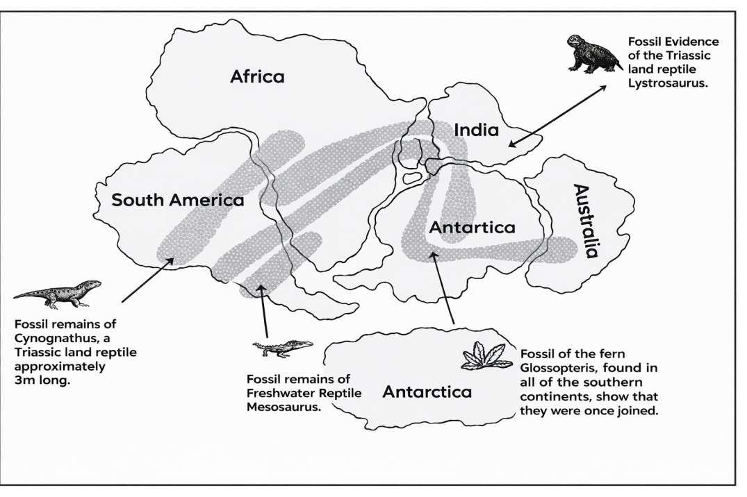
11. Match the List I with List II and select the correct answer by using the codes given below (SEPT 2013)
| List-I (Evidence for continental drift) | List-II (Evidence supporting) |
|---|---|
| A. Paleontological evidence | I. Coastlines of South America and Africa |
| B. Biological evidence | II. Glossopteris |
| C. Jig-saw-fit evidence | III. Lystrosaurus fossils |
| D. Land bridges | IV. Marsupials |
Codes
(1) A-I, B-II, C-III, D-IV
(2) A-IV, B-III, C-II, D-I
(3) A-III, B-II, C-I, D-IV
(4) A-II, B-I, C-IV, D-III
Correct Answer (3):
The correct matching is A-III, B-II, C-I, D-IV.
Palaeontological evidence is based on the study of fossils. Fossils of animals such as Lystrosaurus, found on several widely separated continents, indicate that these landmasses were once connected.
Biological evidence refers to the distribution of organisms and plant remains. Fossils of the ancient plant Glossopteris, discovered in South America, Africa, India, Australia and Antarctica, strongly support continental drift.
Jig-saw-fit evidence is the close geometric matching of continental margins, especially the eastern coast of South America and the western coast of Africa.
Land-bridge theory attempted to explain the presence of similar organisms on different continents by proposing temporary land connections, for example to explain the distribution of marsupials in South America and Australia; however, this view was later rejected in favour of continental drift.