
Exploring Society India and Beyond
Class 6th
NCERT
Language
Choose your preferred language
CLASS 6TH (Social Science)
🎨 Reading Colors
Background
Text Color
Table of Contents
- CH1. Locating Places on the Earth
- A Map and its Component
- Mapping the Earth
- Understanding Time Zones
- CH2. Oceans and Continents
- The Distribution of Water and Land on the Earth
- Continents
- Oceans and Life
- CH3. Landforms and Life
- Introduction
- Mountains
- Plateaus
- Plains
- CH4. Timelines and Sources of History
- How Do We Learn About the Past?
- How Is Time Measured in History?
- What Are the Sources of History?
- The Beginnings of Human History
- The First Crops
- CH5. India, That is Bharat
- How Indians Named India
- How Foreigners Named India
- CH6. The Beginnings of Indian Civilisation
- What Is a Civilisation?
- From Village to City
- Town-Planning
- Water Management
- What Did the Harappans Eat?
- A Brisk Trade
- The End or a New Beginning?
- CH7. India’s Cultural Roots
- The Vedas and Vedic Culture
- Folk and Tribal Roots
- CH8. Unity in Diversity, or ‘Many in the One’
- A Rich Diversity
- Food for All
- Textiles and Clothing
- Festivals Galore
- An Epic Spread
- CH9. Family and Community
- Roles and Responsibilities
- Community
- CH10. Grassroots Democracy – Part 1 (Governance)
- Introduction
- Three Organs of Government
- Three Levels of Government
- Democracy
- CH11. Grassroots Democracy – Part 2 (Local Government in Rural Areas)
- Panchayati Raj System
- Gram Panchayat
- Child-Friendly Panchayat Initiative
- Panchayat Samiti and Zila Parishad
- CH 12. Grassroots Democracy – Part 3 (Local Government in Urban Areas)
- Introduction
- Urban Local Bodies
- CH13. The Value of Work
- CH13. Economic Activities Around Us
- The Classification of Economic Activities into Economic Sectors
CH1. Locating Places on the Earth
A Map and its Component
- A map is a representation or drawing of an area, which may be a small area such as a village or town, a larger area such as a district or state, or a very large area such as India or the whole world; in a map, the surface is viewed as if seen from the top. An atlas is a book or collection of maps.
- There are several kinds of maps: physical maps mainly show natural features such as mountains, oceans and rivers; political maps show details of countries or states, boundaries, cities, etc., for example a map of India with all its States, Union Territories and their capitals; and thematic maps show a specific kind of information.
- Maps have three important components: distance, direction and symbols.
- A huge place can fit on a small piece of paper because of the map’s scale, which tells how much distance on the map represents a certain distance on the ground; for example, if each centimetre on a small city’s map represents 500 metres, the scale is 1 cm = 500 m.
- On the map of India, the scale is shown in the bottom left corner by a ruler with ‘500’ written above its length and ‘km’ on the side; this means that the ruler, measuring 2.5 cm in the printed map, corresponds to 500 kilometres on the ground.
- The actual distance between two points shown on a map depends on the scale used by that map.
- The four arrows at the top right of the small city’s map point to the four cardinal directions or cardinal points: north at the top, and moving clockwise, east, south and west.
- Besides the cardinal directions, intermediate directions are also used: northeast (NE), southeast (SE), southwest (SW) and northwest (NW); most maps simply have an arrow marked with the letter ‘N’, which points to the north direction.
- Symbols are another important component of maps; since there would not be enough space on the map of a large city or country to draw all actual buildings and features, symbols are used to represent them, such as symbols for different kinds of buildings (a railway station, a school, a post office), for roads and railway lines, and for natural elements such as a river, a pond or a forest.
- Symbols allow numerous details to be shown in the limited space available on a map; to make maps easily understood by a variety of users, map makers use specific symbols, and different countries use different sets of symbols.
- The Survey of India, a government body, has fixed a set of symbols for maps of India or parts of India.
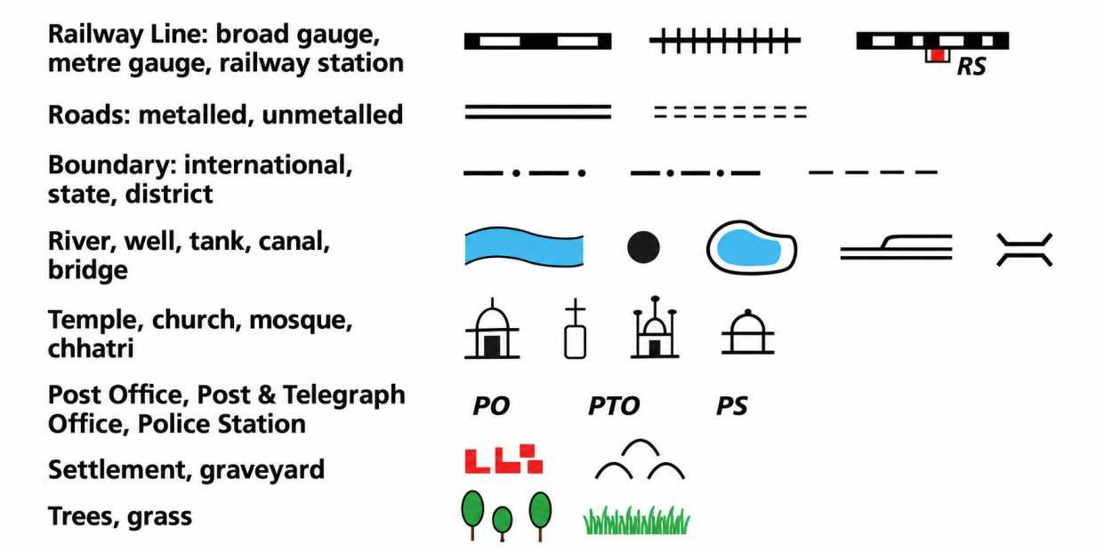
A selection of symbols commonly used in maps
Mapping the Earth
- Mapping the Earth is more difficult than mapping a flat area because our planet is not flat; it nearly has the shape of a sphere. It is called ‘nearly’ spherical because the Earth is not a perfect sphere but is slightly flattened at the poles, although in practice we consider it to be spherical.
- It is not possible to represent a sphere accurately on a flat sheet of paper; for example, if an orange is peeled into three or four large pieces and an attempt is made to flatten them on a table, the pieces cannot be flattened without tearing at the edges.
- A globe is a sphere on which a map is drawn; it may represent the Earth, the Moon, the planet Mars, or the stars and constellations in the sky. The physical globe is generally made of metal, plastic or cardboard.
- Since a globe and the Earth have the same spherical shape, a globe represents the geography of the Earth better than a flat map.
Coordinates:
- A system of coordinates is used to determine the exact location of a place or object using two references; for example, a stationery shop in a market can be located as the 7th shop in the 5th row from the entrance.
- On a chessboard, letters from ‘a’ to ‘h’ and numbers from 1 to 8 are used to mark each square; therefore, a pawn moving from d2 to d4 can be precisely recorded using coordinates.
- A similar system of coordinates is used in maps to determine the location of any place on Earth.
Latitudes:
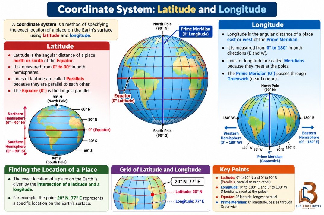
- On a globe, the North Pole and South Pole are the fixed points at the top and bottom; halfway between them is the Equator.
- Latitude measures the distance of a place from the Equator while travelling towards one of the poles.
- An imaginary line running east and west, parallel to the Equator, is called a parallel of latitude; it draws a circle around the Earth.
- The Equator is the largest circle, while the circles formed by parallels of latitude become smaller as we move northward or southward.
- Latitudes are measured in degrees: the Equator is 0°, the North Pole is 90°N, and the South Pole is 90°S.
- Latitude is connected with climate: around the Equator the climate is generally hot or torrid; as latitude increases away from the Equator, the climate becomes more moderate or temperate; and closer to the North or South Pole, the climate becomes colder or frigid.
Longitudes:
- Meridians of longitude are imaginary lines drawn from the North Pole to the South Pole by the shortest possible route; they are all half-circles running from one pole to the other.
- The Earth spins on its axis, so different places experience morning, mid-day, evening or night at the same time; therefore, measuring the longitude of a place also helps in measuring the time at that place.
- To measure longitudes, a reference point called the Prime Meridian is needed; it is also called the Greenwich Meridian because, in 1884, some nations decided that the meridian passing through Greenwich, an area of London in England, would be the international standard Prime Meridian.
- The Prime Meridian is marked as 0° longitude; longitude measures the distance from the Prime Meridian while travelling along the Equator.
- Longitude is also measured in degrees; moving westward or eastward, it increases from 0° to 180°, with the letter ‘W’ or ‘E’ added; for example, New York is at 74°W, Delhi is at 77°E, and Tokyo is at 140°E.
- Latitude and longitude together are the two coordinates of a place and can be used to locate any place on Earth; for example, Delhi lies at 29°N latitude and 77°E longitude (rounded-off values).
- The parallels of latitude and meridians of longitude together form a grid on the globe; these lines are also called grid lines.
Ancient Indian Prime Meridian:
- The Greenwich Meridian was not the first prime meridian; many centuries before Europe, India had its own prime meridian called madhya rekhā, meaning ‘middle line’.
- The madhya rekhā passed through the city of Ujjayinī, today known as Ujjain, which was a reputed centre for astronomy for many centuries.
- Varāhamihira, a famous astronomer, lived and worked in Ujjayinī about 1,500 years ago.
- Indian astronomers were aware of the concepts of latitude and longitude, including the need for a zero or prime meridian; the Ujjayinī meridian became a reference for calculations in Indian astronomical texts.
- Some ancient Indian cities shown on the map are very close to the Ujjayinī meridian, while others are a little away, because measuring longitude required accurate timekeeping, which was not as precise in ancient times as it is today.
Understanding Time Zones
- The Earth rotates from west to east around its axis and makes one full turn every 24 hours; a full turn is 360°, which means the Earth rotates 15° per hour (15 × 24 = 360).
- Meridians of longitude can be marked every 15°; moving eastward from the Prime Meridian, the longitudes are 0°, 15°E, 30°E, 45°E, and so on up to 180°E.
- Each 15° meridian corresponds to a difference of one hour of local time: if it is 12 pm (noon) at Greenwich, it is 1 pm at 15°E, 2 pm at 30°E, and so on.
- Moving westward from the Prime Meridian, local time decreases: it is 11 am at 15°W, 10 am at 30°W, and so on.
- This method can be used to calculate the local time of any place on Earth, but it would not be convenient for a country to use many different local times.
- Therefore, most countries adopt a standard time based on a meridian passing through them.
- Indian Standard Time (IST) is 5 hours 30 minutes (also written as 5.5 hours) ahead of the local time at Greenwich, called Greenwich Mean Time (GMT).
- Standard times around the world are organised into time zones, which broadly follow zones of 15°; however, the lines dividing time zones are not fully straight because they respect each country’s standard time and tend to follow international borders.
- On a world map, the numbers written inside some countries show the number of hours to be added to GMT to get their standard time if they have a positive sign, or subtracted from GMT if they have a negative sign.
- The International Date Line lies approximately at 180° longitude, opposite the Prime Meridian; the +12 and −12 time zones touch each other at this line.
- When crossing the International Date Line by ship or plane, the date on a watch must be changed: travelling eastward, one day is subtracted (for example, from Monday to Sunday); travelling westward, one day is added (for example, from Sunday to Monday).
- The International Date Line is only approximately at 180° longitude because it deviates in some places to avoid dividing a country into two different days.
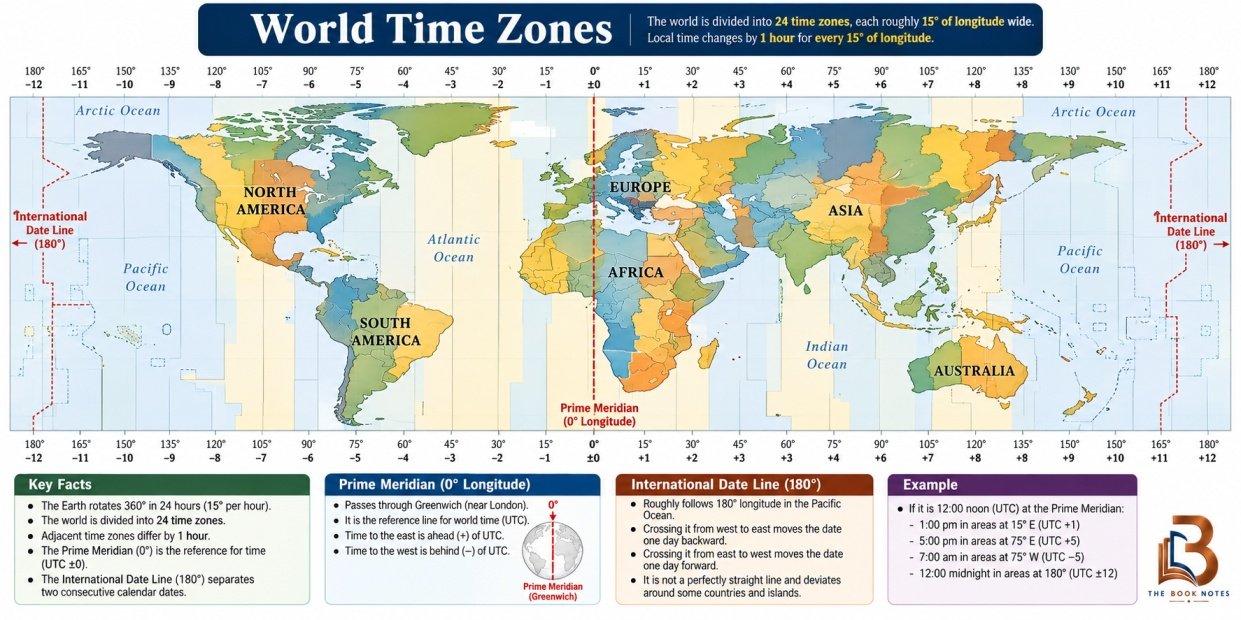
- World Time Zones