
Introduction
Relief refers to the variations in elevation and configuration of the Earth’s surface — mountains, hills, valleys, plateaus, and plains. Since a map is a two-dimensional representation of a three-dimensional landscape, one of the central and most challenging problems in cartography has always been how to effectively convey the third dimension (height/vertical relief) on a flat sheet of paper. Over the history of cartography, several methods have been developed to represent relief, ranging from simple pictorial/qualitative techniques to precise, mathematically accurate quantitative methods.
Classification of Relief Representation Methods
Methods of showing relief are broadly classified into two categories:
- Qualitative methods: Give a general visual impression of relief (its ruggedness, slope, and relative highs/lows) without precise numerical values — e.g., hachures, hill shading, pictorial/relief symbols.
- Quantitative methods: Provide precise, measurable elevation values at specific points or along specific lines — e.g., contours, spot heights, bench marks, layer tinting (hypsometric tinting), and triangulation points.
Hachures and hill shading fall primarily into the qualitative category, while contours represent the quantitative approach, which is why contours have become the standard method in modern scientific and topographical cartography.
Hachures
Meaning and Technique
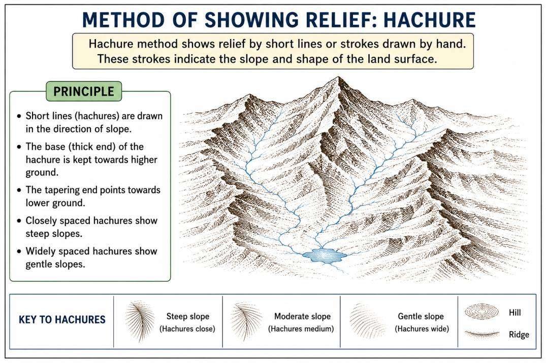
Hachures are a method of depicting relief using short, closely spaced line strokes drawn in the direction of the slope (i.e., in the direction water would flow downhill, perpendicular to the contour lines), where the thickness, length, and spacing of the lines vary systematically with the steepness of the slope.
Principle of Representation
- On steep slopes, the hachure strokes are drawn short, thick, and closely spaced together, creating a dense, dark visual effect that conveys the impression of abrupt, rugged terrain.
- On gentle slopes, the hachure strokes are drawn long, thin, and widely spaced apart, creating a lighter visual effect that conveys the impression of a gradual, gentle incline.
- On flat/level ground, hachures are typically absent altogether, leaving the area blank.
This systematic relationship between line density/thickness and slope angle was formalized in the 18th–19th centuries, notably in a graduated hachure scale developed by cartographers such as Johann Georg Lehmann (a Saxon military cartographer), who established a fixed proportional relationship between hachure line thickness/spacing and specific degrees of slope angle, allowing a degree of standardization to what was otherwise a fairly artistic technique.
Merits of the Hachure Method
- Provides an immediate, intuitive, and vivid visual/pictorial impression of terrain ruggedness, clearly distinguishing steep mountainous areas from gentler slopes at a glance.
- Effective for conveying the general “lay of the land” — the overall pattern and orientation of ridges, valleys, and slopes — in a way that is aesthetically engaging and easy for a general (non-technical) map reader to interpret.
- Historically important and widely used on military and topographical maps of the 18th and 19th centuries (e.g., early Ordnance Survey maps of Britain, and Austrian/German military cartography).
Limitations of the Hachure Method
- Does not provide precise, measurable elevation values — a hachured map cannot tell the reader the exact height of a particular point or the exact height difference between two points; it conveys only a relative, qualitative impression of slope and ruggedness.
- Extremely labour-intensive and time-consuming to draft, requiring considerable artistic skill, making it impractical for the systematic mapping of large areas in the modern era.
- Can make a map appear visually cluttered or “busy,” especially in areas of highly complex, rugged terrain, sometimes obscuring other important map details (drainage, settlements, transport lines).
- Provides no information about absolute elevation (height above sea level) — two areas of identical steepness would appear identical regardless of whether one is at sea level and the other at a high plateau.
- Has been almost entirely superseded in modern topographical cartography by contour-based methods, which provide precise quantitative data more efficiently, especially since the advent of aerial photogrammetry and digital elevation modelling.