
Basic Principles of Surveying
Introduction
Surveying is the science, art, and technique of accurately determining and recording the relative positions of points on, above, or below the Earth’s surface, either in terms of horizontal distances, elevations, angles, or geographic coordinates. In geography, surveying forms the empirical backbone of fieldwork — the direct, first-hand collection of spatial, physical, and socio-economic data from the landscape itself — which distinguishes geography from a purely theoretical or library-based discipline.
Basic Principles of Surveying
Surveying, regardless of the specific method or instrument used, rests on a small set of foundational principles that ensure accuracy, consistency, and error control:
Working from Whole to Part:
This is considered the most fundamental principle of surveying. It requires that the surveyor first establish a small number of highly accurate primary/major control points covering the entire area to be surveyed (through precise triangulation or traversing), and only thereafter proceed to fill in the minor, subsidiary details with reference to this established framework. This ensures that small errors made during detailed, localized survey work remain confined and localized, rather than accumulating and magnifying across the entire survey area — a critical safeguard against compounding error.
Location of Points by Measurement from Two Points of Reference:
Any new, unknown point can be accurately and unambiguously fixed in position by measuring its distance and/or angle from two already-known reference points, applying basic principles of geometry (triangulation) — this underlies most classical surveying methods.
Principle of Providing Adequate Control:
A survey network must include a sufficient number of well-distributed control points (of known, precisely determined position) to serve as the framework for all subsequent, more detailed measurement — ensuring the overall survey maintains geometric consistency and accuracy.
Principle of Consistency of Accuracy:
All parts of a survey should be conducted with a uniform, consistent standard of accuracy appropriate to the purpose of the survey — it is neither useful nor economical to measure some parts of a survey with extreme precision while other parts are measured only roughly, as the overall accuracy of the survey is limited by its least accurate component.
Principle of Independent Checks:
Good surveying practice requires that measurements be independently verified/cross-checked wherever possible (e.g., closing a traverse back to its starting point, or cross-checking a triangulated position through an independent set of measurements), to detect and correct errors before they propagate further.
Economy and Purpose-Appropriateness:
The degree of precision, choice of instruments, and method employed should be appropriate to the purpose and required accuracy of the specific survey — a reconnaissance/exploratory survey requires far less precision than a cadastral (land-ownership boundary) or engineering survey.
Types of Surveying
Surveying can be classified according to several different criteria — the instrument/method used, the nature of the terrain, the purpose of the survey, and the underlying reference framework.
Based on the Curvature of the Earth Considered:
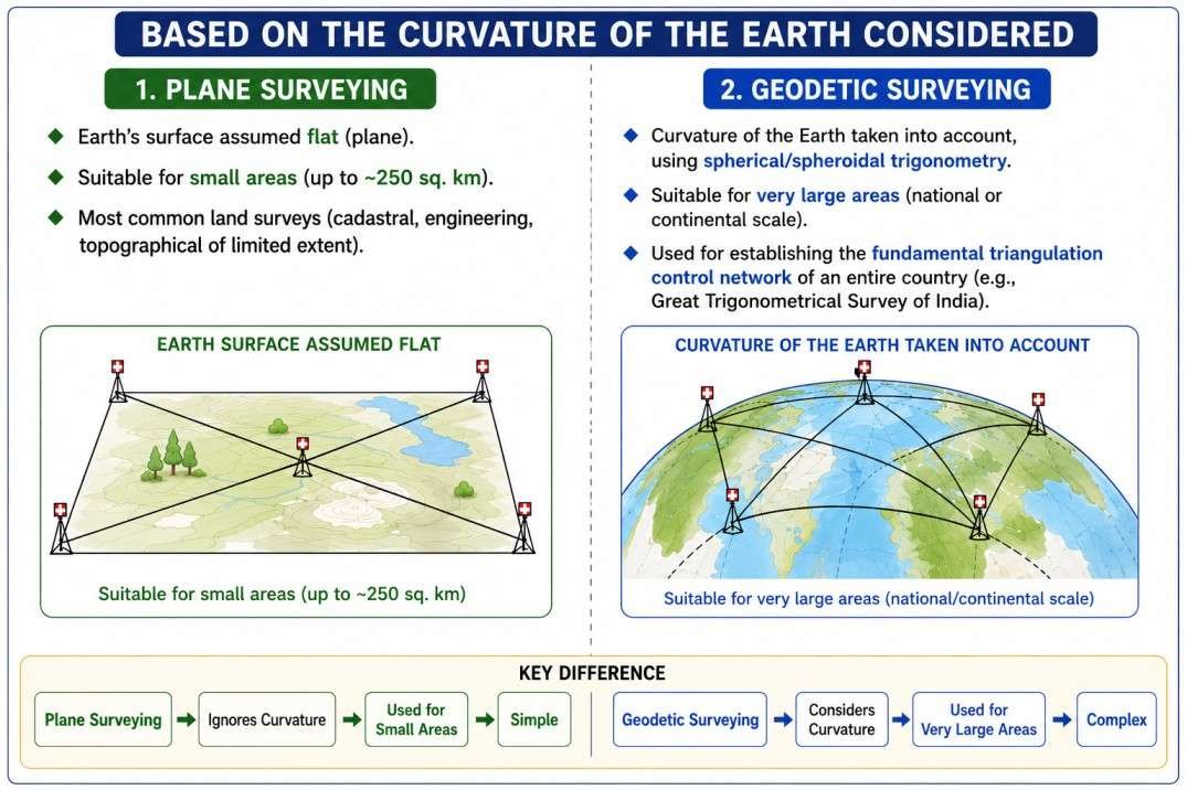
- Plane Surveying: Assumes the Earth’s surface to be flat/plane, ignoring the curvature of the Earth — a reasonable simplifying assumption for surveys covering relatively small areas (up to roughly 250 sq. km), where the resulting error from ignoring curvature is negligible. Most common land surveys (cadastral, engineering, topographical surveys of limited extent) are plane surveys.
- Geodetic Surveying: Takes the curvature of the Earth into account, using spherical/spheroidal trigonometry, and is employed for surveys covering very large areas (national or continental scale), such as establishing the fundamental triangulation control network of an entire country (e.g., the historic Great Trigonometrical Survey of India).
Based on the Method/Instrument Employed:
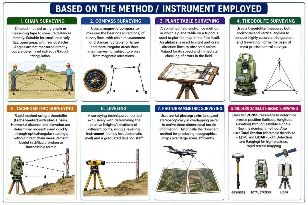
- Chain Surveying: The simplest method, using only a chain or measuring tape to measure distances directly, suitable for small, relatively flat, open areas with few obstacles; angles are not directly measured but are indirectly determined through triangulation of measured lines.
- Compass Surveying: Uses a magnetic compass to measure the bearings (directions) of survey lines, combined with chain measurement of distances; suitable for larger and more irregular areas than pure chain surveying, though subject to inaccuracies from local magnetic attraction/interference.
- Plane Table Surveying: A combined field-and-office method in which a flat drawing board (plane table), mounted on a tripod, is used to directly plot the map in the field itself while the survey is conducted, using a sighting instrument called an alidade to sight and draw direction lines to observed points — valued for its speed and the fact that errors can be spotted immediately in the field.
- Theodolite Surveying: Uses a theodolite (a precision instrument for measuring both horizontal and vertical angles) to conduct highly accurate triangulation and traversing, forming the basis of most precise control surveys.
- Tacheometric Surveying: A rapid method of surveying using a theodolite (tacheometer) fitted with stadia hairs, allowing both horizontal distance and elevation to be determined indirectly and quickly through optical/angular readings, without the need for direct chain measurement — particularly useful in difficult, broken, or inaccessible terrain.
- Leveling: A specific surveying technique concerned exclusively with determining the relative heights/elevations of different points, using a leveling instrument (dumpy level/automatic level) and a graduated leveling staff.
- Photogrammetric Surveying: Uses aerial photographs (analyzed stereoscopically, in overlapping pairs, to derive three-dimensional terrain information) as the primary data source, historically the dominant method for producing topographical maps over large areas efficiently.
- Modern Satellite-Based Surveying: Uses GPS/GNSS (Global Positioning System/Global Navigation Satellite System) receivers to determine precise position (latitude, longitude, elevation) through satellite signal triangulation, now the dominant method in contemporary professional and geographic survey practice, alongside Total Station instruments (which electronically combine theodolite angle measurement with electronic distance measurement, EDM) and LiDAR (Light Detection and Ranging) for high-precision, rapid terrain mapping.